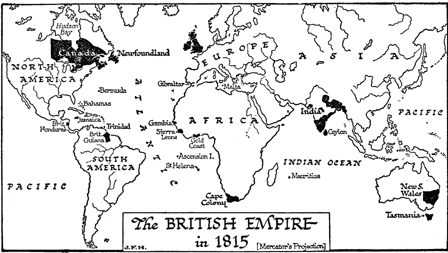
Description: A world map of the British Empire in 1815 on a Mercator's Projection. The territorial claims of Britain at the time are shown in black. "The British Empire in 1815 consisted of the thinly populated coastal river and lake regions of Canada, and a great hinterland of wilderness in which the only settlements as yet were the fur-trading stations of the Hudson Bay Company, about a third of the Indian peninsula, under the rule of the East India Company, the coastal districts of the Cape of Good Hope inhabited by blacks and rebellious-spirited Dutch settlers; a few trading stations on the coast of West Africa, the rock of Gibraltar, the island of Malta, Jamaica, a few minor slave-labour possessions in the West Indies, British Guiana in South America, and, on the other side of the world, two dumps for convicts at Botany Bay in Australia and in Tasmania." — Wells, 1921, p. 451.
Place Names: A Complete Map of Globes and Multi-continent, Africa, �Asia, �Australia, �Europe, �North America, �South Americ
ISO Topic Categories: boundaries,
location,
oceans,
inlandWaters
Keywords: The British Empire in 1815, physical, �political, physical features, major political subdivisions, boundaries,
location,
oceans,
inlandWaters, Unknown, 1815
Source: H. G. Wells, The Outline of History (New York, NY: The Macmillan Company, 1921) 976
Map Credit: Courtesy the private collection of Roy Winkelman |
|