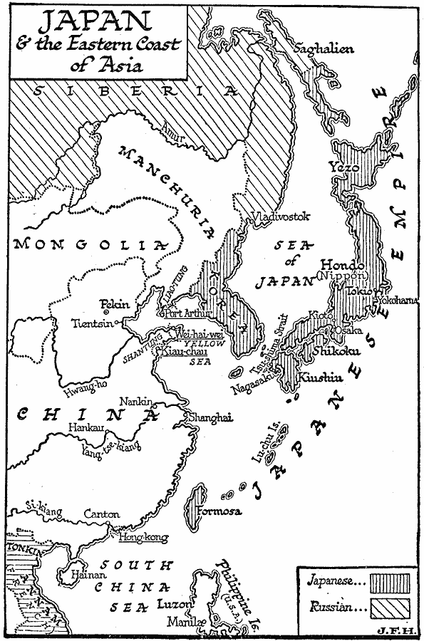
Description: A map of Japan and the eastern coast of Asia at the end of the Russo-Japanese War (1904–1905). The map shows the territories controlled by Japan from the southern half of the Saghalien (Sakhalin) Island, the Korean Peninsula, and the island chain of the Lu-chu Islands (Ryukyu) to Formosa (Taiwan). The map also shows the foreign possessions in the region at the time, including French Tonkin and Annam (French Indo-China), the United States in the Philippines, the British Hong Kong and Wei-hai-wei, the German Kiau-chau, and the Russian expansion into Manchuria, with the warm water port of Port Arthur as the intended goal that sparked the Russo-Japanese War. "In 1898 Germany descended upon China, and, making the murder of two missionaries her excuse, annexed a portion of the province of Shang-tung. Thereupon Russia seized the Liao-tung peninsula, and extorted the consent of China to an extension of her trans-Siberian railway to Port Arthur; and in 1900 she occupied Manchuria. Britain was unable to resist the imitative impulse, and seized the port of Wei-hai-wei (1898). How alarming these events must have been to every intelligent Japanese a glance at the map will show. They led to a war with Russia which marks an epoch in the history of Asia, the close of the period of European arrogance." — Wells, 1921, p. 994.
Place Names: Eastern Asia, China, �Mongolia, �Japan, �Korea,�Taiwan, �Formosa, �Manchuria, �Russia, �Phillipine
ISO Topic Categories: boundaries,
oceans,
location,
inlandWaters
Keywords: Japan and East Asia , physical, �political, physical features, major political subdivisions,
country borders, boundaries,
oceans,
location,
inlandWaters, Unknown, 1905
Source: H. G. Wells, The Outline of History (New York, NY: The Macmillan Company, 1921)
Map Credit: Courtesy the private collection of Roy Winkelman |
|