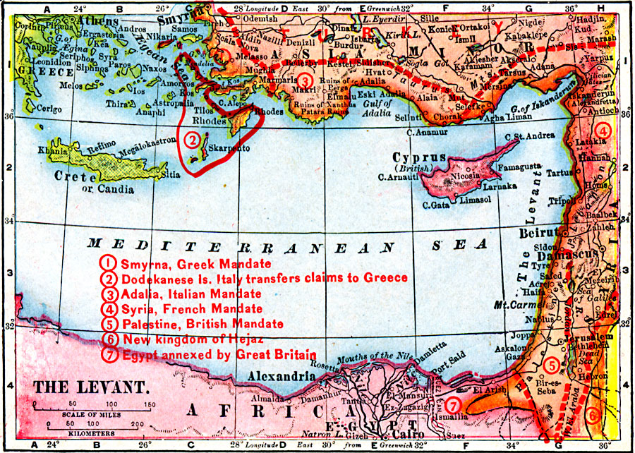
Description: A map from 1919 of the Levant region (Asia Minor, Syria, and Palestine) showing borders and territories after World War I. The map shows principal cities and ports, railroads, mountain systems, rivers, islands, and coastal features, including Smyrna under Greek mandate, the Dodekanes Islands transferred from Italian claim to Greece, Adalia under Italian mandate, Syria under French mandate, Palestine under British mandate, the new Kingdom of Hejaz, and the portion of Egypt annexed by Great Britain.
Place Names: Southwest Asia, Africa, �Asia Minor,�Beirut, �Cairo, �Damascus, �Egypt, �Syri
ISO Topic Categories: boundaries,
inlandWaters,
location,
oceans
Keywords: The Levant, physical, �political, �borders, �boundaries, �historical, �World War I, �WWI, physical features, country borders, WWI, boundaries,
inlandWaters,
location,
oceans, Unknown, 1914–1919
Source: Merton M. Wilner, A New Atlas of the New World Corrected According to the Peace Terms Together with a Graphic Story of the Great War 1914-1919 (New York, NY: The Christian Herald, 1919) 9
Map Credit: Courtesy the private collection of Roy Winkelman |
|