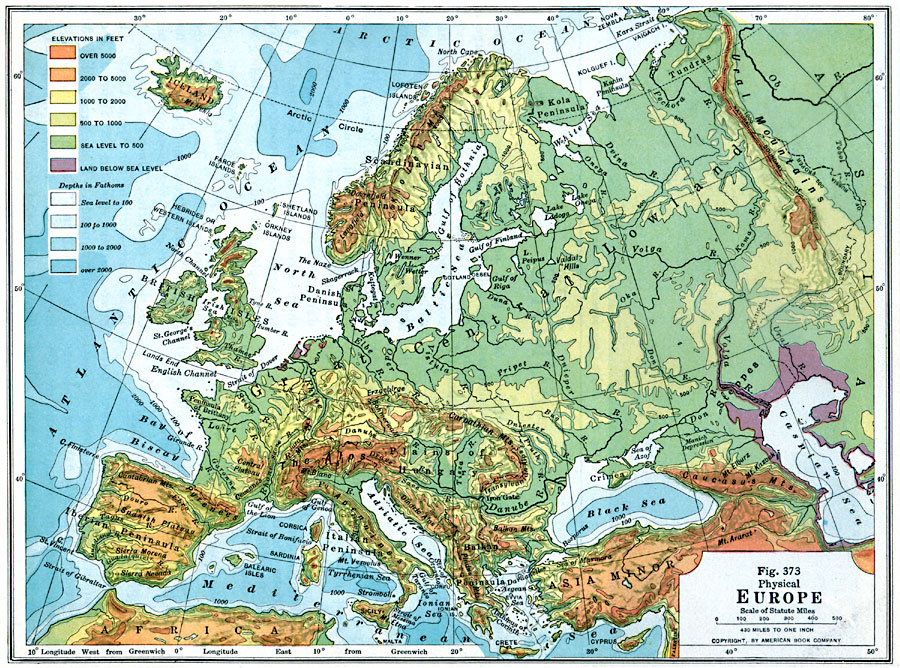
Description: A physical map of Europe from 1916 showing color–coded elevations and water depths for the area extending from Iceland to the Ural Mountains in Russia Proper, and the Arctic Circle to the Mediterranean Sea. Land elevation colors range from below sea level to over 5000 feet, and water depth colors range from sea level to over 2000 fathoms. Major rivers, bodies of water, mountain systems and prominent peaks, and major landform features such as lowlands, plains, and highlands are shown. The map also shows both the political and natural (Ural Mountains) boundaries between Europe and Asia.
Place Names: A Complete Map of Europe, Iceland, Scandinavian Peninsula, Arctic Ocean, Kola Peninsula, Gulf of Bothnia, Ural Mountains, Great Central Lowland, North Sea, British Isles, Iberian Peninsula, Spanish Plains, Pyrenees, Bay of Biscay, Alps, Italian Peninsula, Mediterranean Sea, Tyrrhenian Sea, Adriatic Sea, Ionian Sea, Aegean Sea, Balkan Peninsula, Black Sea, Caspian Sea, Caucasus Mountains, Carpathian Mountains
ISO Topic Categories: elevation,
location,
oceans,
inlandWaters
Keywords: Physical Europe, physical, physical features,
topographical, elevation,
location,
oceans,
inlandWaters, Unknown, 1916
Source: Albert Perry Brigham & Charles T. McFarlane, Essentials of Geography (New York, NY: American Book Company, 1916) 262
Map Credit: Courtesy the private collection of Roy Winkelman |
|