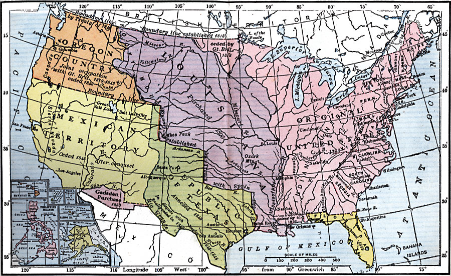
Description: A map from 1920 of the United States and its territories between 1783 and 1900 showing the nation's expansion and date of acquisition of each new territory or possession. The map is color–coded to show the progression from the original thirteen States and Northwest Territory, the French cession of Louisiana in 1803, the Oregon Country, Spanish cession of Florida in 1819, Texas annexation in 1845 and cession in 1850, the first Mexican cession in 1848, and the Gadsden Purchase in 1853. Includes insert maps detailing the territories of Alaska, Samoa Islands, Wake Island, Guam Island, Hawaiian Islands, and Philippine Islands.
Place Names: Growth of Nation, Philippines, �Alaska, �Hawaii, �Gadsen Pruchase, �Texas, �Florida, �Louisiana Purchase, �Oregon Country, �Mexican Territory, �Philadelphia, �New York, �Boston, �Charleston, �St. Louis, �Mexican Cession, �Original Colonies, �Hawai
ISO Topic Categories: boundaries,
location,
inlandWaters,
oceans
Keywords: Territorial Acquisitions of the United States, physical, �political, physical features, major political subdivisions,
country borders, boundaries,
location,
inlandWaters,
oceans, Unknown, 1783–1900
Source: Robert Hall, Harriet Smither, and Clarence Ousley, A History of the United States (Dallas, TX: The Southern Publishing Company, 1920) 458-459
Map Credit: Courtesy the private collection of Roy Winkelman |
|