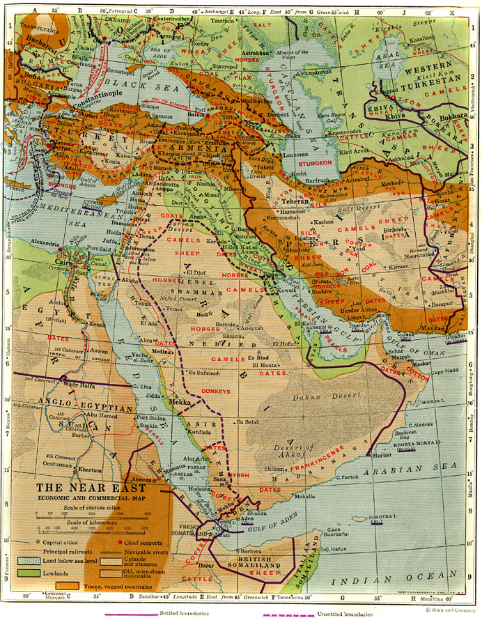
Description: A map of the Near East from 1920 showing economic and commercial activities of the region, including export information. This map shows local agricultural, fishery, natural, and mineral resources, major cities and capitals, trade centers, chief seaports, direction of trade, principal railways, and navigable rivers. The map is color–coded to show terrain features that effect trade, including deserts and marshlands, lands below sea level, lowlands, uplands and plateaus, older worn down mountains, and younger rugged mountains. Locations in latitude and longitude of important world trade centers are given at their corresponding positions along the borders of the map.
Place Names: Southwest Asia, Asia, �Europe, �Egypt, �Anglo-Egyptian Sudan, �Hejaz, �Asir, �Yemen, �Eritrea, �British Somaliland, �Italian Somaliland, �French Somaliland, �Arabia, �Palestine, �Mesopotamia, �Persia, �Turkey,
ISO Topic Categories: boundaries,
inlandWaters,
location,
oceans,
economy
Keywords: Economic and Commercial Map of the Near East, physical, �political, �transportation, physical features, country borders, railroads,
water routes, boundaries,
inlandWaters,
location,
oceans,
economy, Unknown, 1920
Source: Wallace W. Atwood, New Geography: Book Two (Boston, MA: Ginn and Company, 1920) 237
Map Credit: Courtesy the private collection of Roy Winkelman |
|