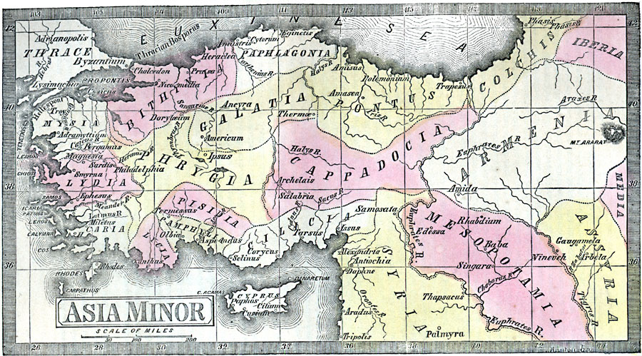
Description: A map from 1859 showing ancient Asia Minor. The map coverage is from the Euxine Sea, or Black Sea, to Syria, and the coastal region of the Aegean and Mediterranean inland to Armenia. The island of Cypress is shown, as well as important cities of the region, major rivers, and islands. "Asia Minor, or Lesser Asia, a celebrated region of antiquity, embraced the great peninsula of Western Asia, about equal in area to that of Spain, and bounded north by the Black Sea, east by Armenia and the Euphrates, south by Syria and the Mediterranean, and west by the Euxine [&Aelig;gean ] Sea or Archipelago. The divisions by which it is best known in history are the nine coast provinces, Cilicia, Pamphylia, and Lycia, on the Mediterranean; Caria, Lydia, and Mysia on the &Aelig;gean; Bithynia, Paphlagonia, and Pontus, on the Euxine; and the four interior provinces, Galatia, Cappadocia, Phrygia, and Pisidia. All of these were, at times, independent kingdoms, and at others, dependent provinces." — Wilson, 1859, p. 570.
Place Names: Southwest Asia, Armenia, �Appadocia, �Assyria, �Bithinia, �Cappadocia, �Cilicia, �Galatia, �Lycia, �Lydia, �Mesopotamia, �Pamphylia, �Phrygia, �Pisidia, �Syri
ISO Topic Categories: inlandWaters,
location,
oceans
Keywords: Asia Minor, historical, country borders, inlandWaters,
location,
oceans, Unknown, 2000 BC
Source: Marcius Willson, Willson's Outlines of History (New York, NY: Ivison & Phinney, 1859) 571
Map Credit: Courtesy the private collection of Roy Winkelman |
|