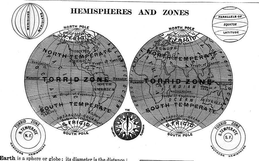
Description: A double hemisphere map of the earth from 1872 showing the world displayed in western and eastern hemispheres. This mapping convention of dividing the earth, bound by the 20° W and 160° E meridians, shows the "Old World" and "New World" with a minimum disruption of the landmasses. The frigid, temperate, and torrid zones indicated on this map are based on degrees of latitude rather than true temperature measurements. The map includes illustrations of the meridians of longitude and parallels of latitude for a globe, both north and south polar views showing the frigid, temperate, and torrid zones, and a mariner's compass.
Place Names: A Complete Map of Globes and Multi-continent, Africa, �Antarctica, �Asia, �Australia, �Europe, �North America, �South Americ
ISO Topic Categories: climatologyMeteorologyAtmosphere,
location,
oceans
Keywords: Hemispheres and Zones of the Earth, meteorological, �physical, physical features, climate, climatologyMeteorologyAtmosphere,
location,
oceans, Unknown, 1872
Source: James Monteith, Comprehensive Geography (New York, New York: A. S. Barnes and Company, 1872) 9
Map Credit: Courtesy the private collection of Roy Winkelman |
|