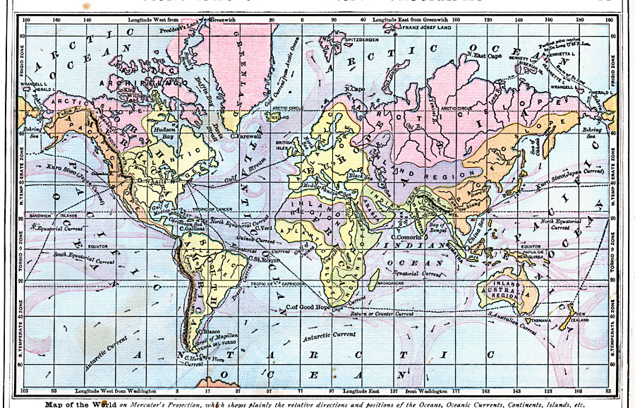
Description: A world map on Mercator's Projection from 1872 "which shows plainly the relative directions and positions of the Oceans, Oceanic Currents, Continents, Islands, etc." and includes temperature zones and drainage basins of the earth. The map shows the relative directions and positions of the oceans and oceanic currents. Red lines show warm currents; white lines, cold water. Arrows show the direction in which the currents flow. The temperature zones (frigid, temperate, and torrid) based on latitudes are shown in the east and west borders of the map. The map is color-coded to show the drainage slopes of the Pacific (orange), Atlantic (yellow), Arctic (pink), and Indian (green) oceans, and inland drainage that does not reach the ocean (purple). The black-dotted lines show principal routes at the time around the world from New York, including the route around Cape of Good Hope (Africa), Australia, to San Francisco, the route to Liverpool, Mediterranean Sea, Suez Canal, Bombay, China, and Japan to San Francisco, and the pre-Panama Canal routes from San Francisco to New York via either the Cape Horn or overland routes. This map also shows the route of George W. DeLong from San Francisco to the Lena delta (Siberia) aboard the USS Jeannette on his ill-fated voyage to discover a route to the North Pole. Longitude from Greenwich is shown at the top of the map, longitude from Washington at the bottom.
Place Names: A Complete Map of Globes and Multi-continent, Africa, �Antarctica, �Asia, �Australia, �Europe, �North America, �South Americ
ISO Topic Categories: oceans,
location,
inlandWaters
Keywords: Ocean Currents, Temperature Zones, and Drainage Basins of the World, physical, �hydrological, kClimate, physical features, currents, oceans,
location,
inlandWaters, Unknown, 1872
Source: James Monteith, Comprehensive Geography (New York, New York: A. S. Barnes and Company, 1872) 11
Map Credit: Courtesy the private collection of Roy Winkelman |
|