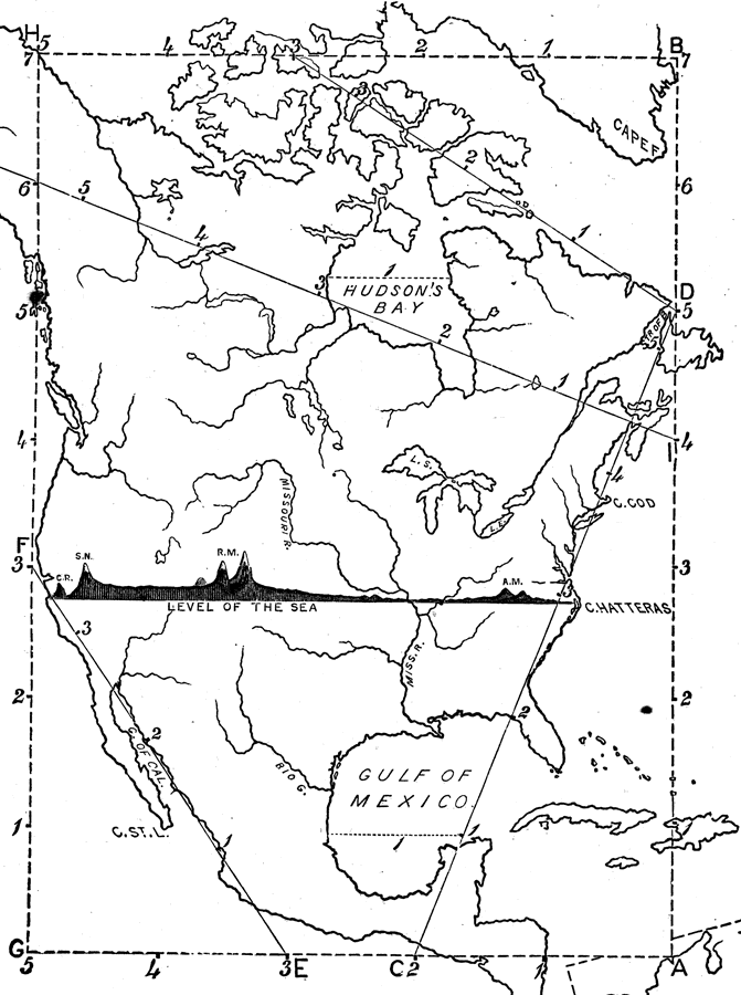
Description: A map exercise from 1872 for drawing North America. The map shows the general outline of the coasts, major waters and rivers, and a vertical profile cross–section of the continent from the San Francisco Bay area to Cape Hatteras. "General Directions for Drawing the Continents — Make a scale by marking on a slip of paper or pasteboard the measures 1, 2, 3, etc., as on the sides of this map. Every measure on the maps of the continents represents six hundred miles. All names in black type are to be marked on the drawing. Pupils should mark on each river, ocean, bay, gulf, strait, etc., the first syllable of its name, when there is not room enough for the full word. As an exercise in spelling, the full name of each abbreviated word may be written on the margin of the drawing, before the recitation closes. Note — Do not draw the measurement lines. The marking of the points indicated will be sufficient." "To Draw North America. Begin at A: 1 measure north of A, draw Hayti: 5 ms. north, draw Newfoundland and the Strait of Bellisle. Between 6 and 7 draw the eastern coast of Greenland. From C measure to D, marking the points 1, 2, 3, 4, 5. Through 1 draw the extremity of the Peninsula of Yucatan. 1 ms. west of this point draw the western coast of the Gulf of Mexico. Draw Campeachy Bay, the Bay of Honduras, and the Isthmus of Panama, and Cuba. At 2 draw the Peninsula of Florida. Mark 3 on the line C D, and locate Cape Hatteras. Near 4, mark Cape Cod: and near 5 draw the Gulf of St. Lawrence and Nova Scotia, and complete the eastern coast. From B measure 5 ms. to H, and draw the islands along the Arctic coast. From G, measure 3 ms. and mark San Francisco; and a little to the north, Cape Mendocino, the western cape of California; opposite 4, draw Vancouver's Island; at 5, Queen Charlotte's Island. At 7 is near the northeastern coast of Alaska. From E to F, mark the points 1, 2, and 3, and draw the Gulf and Peninsula of California and Cape St. Lucas. Complete the southern coast of the continent. Draw James Bay, Hudson Bay, Great Slave Lake, and Mackenzie River, according to the line I J, and complete the northern part of the continent. When the boundaries are drawn, add the mountains, rivers, countries, bays and gulfs, capes, islands, and cities: then the section from Cape Hatteras to the Pacific Ocean, showing elevations above the level of the sea." — Monteith, 1872, p. 17.
Place Names: A Complete Map of North America, Bahamas, �Canada, �Cuba, �Mexico, �United State
ISO Topic Categories: location,
inlandWaters,
oceans
Keywords: Drawing North America, physical, kMapSkills, physical features, location,
inlandWaters,
oceans, Unknown, 1872
Source: James Monteith, Comprehensive Geography (New York, NY: A. S. Barnes and Company, 1872) 17
Map Credit: Courtesy the private collection of Roy Winkelman |
|