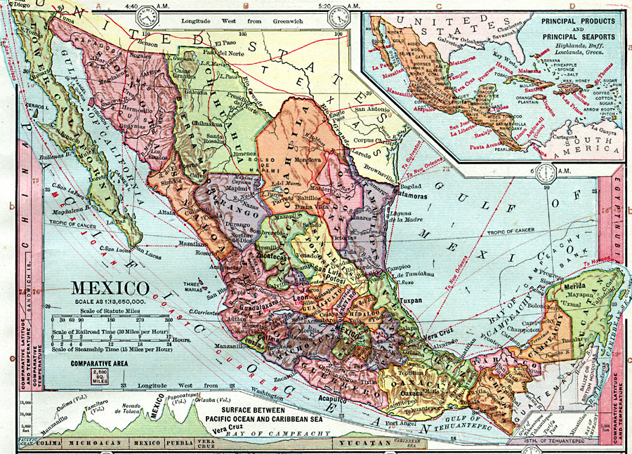
Description: A map from 1872 of Mexico, showing states and state capitals, major cities, towns, and ports, railroads, lakes and rivers, mountain systems, terrain, and coastal features. Steamship routes to major ports are shown, with distances marked along the routes based on a travel speed of 15 miles per hour. Railroad distances are also given based on a travel speed of 30 miles per hour. The map shows the Pacific Mexican coastal current, latitude and temperature comparisons to other countries, and local time zones based on noon Greenwich. Longitudes from Greenwich are given at the top of the map, and from Washington at the bottom. An insert map shows principal products and seaports of Mexico and the West Indies, and is color–coded to show general highlands in buff and lowlands in green. Two charts at the bottom of the map show vertical profiles, one from the Pacific at Manzanillo, Colima, across the Bay of Campeachy (Campeche) to the Yucatan, and a second across the Isthmus of Tehuantepec. A block equaling 2,500 square miles at the same map scale is given for comparative area size.
Place Names: Mexico, Mexico City, �Merida, �La Paz, �Veracruz, �Tampico, �Monterrey, �Acapulc
ISO Topic Categories: boundaries,
oceans,
location,
inlandWaters,
transportation,
elevation,
farming,
economy,
climatologyMeteorologyAtmosphere
Keywords: Mexico, physical, �hydrological, �transportation, �statistical, �meteorological, physical features, county borders, water routes, temperature, currents, boundaries,
oceans,
location,
inlandWaters,
transportation,
elevation,
farming,
economy,
climatologyMeteorologyAtmosphere, Unknown, 1872
Source: James Monteith, Comprehensive Geography (New York, NY: A. S. Barnes and Company, 1872) 51
Map Credit: Courtesy the private collection of Roy Winkelman |
|