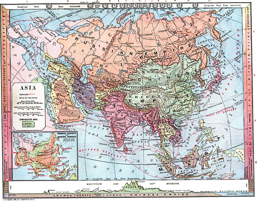
Description: A map of Asia from 1872, showing physical features including mountain systems, deserts, lakes, rivers with direction of flow, coastal features, and ocean currents, political boundaries and foreign possessions at the time, and commercial canals, railway and steamship routes. The map includes scales to determine the amount of time required to travel any distance by railway or steamship based on a travel speed of 30 miles per hour for trains and 15 miles per hour for ships. Steamship routes are marked to show the length of time in days required to travel from Liverpool, England, or Marseilles, France, through the Suez Canal and throughout Asia to Tokyo, Japan. Anchor symbols indicate the head of navigable waters on rivers. Isotherms of mean annual temperature in degrees Fahrenheit are given across Asia, with comparative mean temperatures for equivalent latitudes of other regions of the world given on the side margins of the map. Clock symbols at the top of the map show the time across the longitudes based on noon, London. An inset map shows the principal seaports and products of the region, with lines indicating the northern limits of rice, vine, wheat, and tree production. General elevations are given on this inset, with green indicating lowlands and buff tints indicating highlands. A chart at the bottom of the map shows a cross-section of Asia along latitude 30° North (approximately from the Suez Canal to the Liu Kiu Islands south of Japan). This chart shows elevations above sea level in feet, and water depths. An outline map of Kansas at the same map scale is included to show comparative area size.
Place Names: A Complete Map of Asia, India, �Russian Empire, �Chinese Empire, �Afghanistan, �Bokhara,�Persia, �Arabia, �Turkey, �Oman,�Anam, �Empire of Japan, �Corea, �Thibet Empire,
ISO Topic Categories: boundaries,
oceans,
location,
inlandWaters,
elevation,
farming,
economy,
climatologyMeteorologyAtmosphere,
transportation
Keywords: Physical, Political, and Economic Asia, physical, �political, �transportation, �meteorological, �hydrological, kComparativeArea, kEconomic, physical features, country borders, water routes,
railroads, temperature, currents, boundaries,
oceans,
location,
inlandWaters,
elevation,
farming,
economy,
climatologyMeteorologyAtmosphere,
transportation, Unknown, 1872
Source: James Monteith, Comprehensive Geography (New York, NY: A. S. Barnes and Company, 1872) 76
Map Credit: Courtesy the private collection of Roy Winkelman |
|