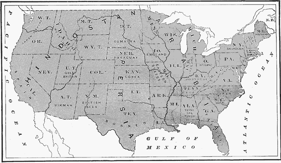
Description: A map from 1872 of the United States used to illustrate the comparative area sizes of the states to other countries in the world. The map shows state and territory boundaries at the time (Dakota, Montana, Washington, Idaho, Wyoming, Utah, Oklahoma, New Mexico, and Arizona were not yet states), with comparisons to Hindostan or India (western states), the Japan Empire (Washington Territory and Oregon), West Indies (Idaho Territory), Great Britain (Utah Territory), British Isles (New Mexico Territory), Spain (California), Birmah or Myanmar (Arizona Territory), Sumatra (Dakota Territory), Paraguay (Nebraska), Corea or Korea (Kansas), Borneo (Texas), Persia (Nebraska, Kansas, Oklahoma Territory, and Texas), Arabia (eastern states), England (Iowa), Ireland (Indiana), Iceland (Ohio), Scotland (Maine), Greece (New Hampshire and Vermont), Saghalien Peninsula (New York), Portugal (Kentucky), Cuba (Tennessee), Java (North Carolina), Haiti (South Carolina), Terra del Fuego (Alabama), and Italy (Georgia and Florida).
Place Names: A Complete Map of the United States, Maine, �New York, �Florida, �Texas, �California, �Washington, �Kansas, �Hindostan, �Persia, �comparative size, �comparative are
ISO Topic Categories: boundaries,
oceans,
location,
inlandWaters
Keywords: Comparative Areas of the United States and Other Countries, physical, kComparativeArea, physical features, boundaries,
oceans,
location,
inlandWaters, Unknown, 1872
Source: James Monteith, Comprehensive Geography (New York, NY: A. S. Barnes and Company, 1872) 104
Map Credit: Courtesy the private collection of Roy Winkelman |
|