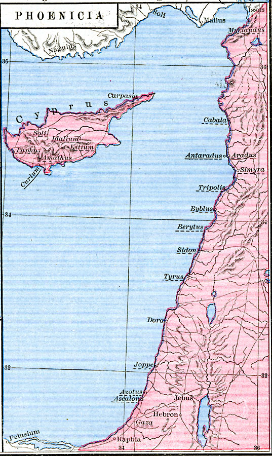
Description: A map of the territory of Phoenicia around 1450 BC, which included the island of Cyprus. The map shows important historical cities of the time and rivers, using name forms (hieroglyphic, cuneiform, biblical, classical, and modern) where appropriate. The names of Phoenician towns are underlined with a dashed line. "A narrow but fertile strip of land, from ten to fifteen miles in breadth, and one hundred and fifty in length, shut in between Lebanon and the sea, was the home of the Phoenicians, who called it Canaan, ‘the lowlands.’ [...] The principal towns of this confederacy were: Acco, Tyre, Sidon, Tripolis, and Aradus. These cities were the first trading communities the world had seen. Their power and wealth, and even their existence, depended on commerce. Their colonies were originally mere marts, and their voyages of discovery were undertaken in the interest of trade. The tin of Britain, the silver of Spain, and the pearls and ivory of India, all flowed into their harbors." — Labberton, 1886, p.9.
Place Names: Palestine, Ascalon, �Cabala, �Cypress, �Gaz
ISO Topic Categories: oceans,
location,
inlandWaters
Keywords: Phoenicia, borders, oceans,
location,
inlandWaters, Unknown, about 1450 BC
Source: Robert H. Labberton, New Historical Atlas and General History (New York, NY: Townsend MacCoun, 1886) Plate III
Map Credit: Courtesy the private collection of Roy Winkelman |
|