mapsMaps ETC Site map
 Maps ETC > Asia > A Regional Map of Asia > The March of Cyris Minor and the Retreat of the 10,000 under Xenophon, 401 B.C.
Site Map 

The March of Cyris Minor and the Retreat of the 10,000 under Xenophon, 401 B.C.

The March of Cyris Minor and the Retreat of the 10,000 under Xenophon


Title: The March of Cyris Minor and the Retreat of the 10,000 under Xenophon
Projection: Unknown,
Source Bounding Coordinates:
W: 25 E: 45 N: 40 S: 35

Main Map Page
Zoomify Version
B/W PDF Version
Color PDF Version
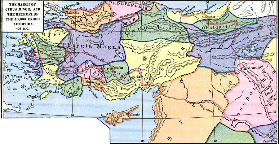
Description: A map of ancient Persia showing the March of Cyris Minor, and the Retreat of the 10,000 under Xenophon in 401 BC.
Place Names: A Regional Map of Asia, Armenia, Bithynia, Cilicia, Cyprus, Lycia, Lydia, Mesopotamia, Phrygia Magna, Syri
ISO Topic Categories: oceans, location, inlandWaters, boundaries
Keywords: The March of Cyris Minor and the Retreat of the 10,000 under Xenophon, borders, political, major political subdivisions, oceans, location, inlandWaters, boundaries, Unknown, 401 B.C.
Source: Robert H. Labberton, New Historical Atlas and General History (New York, NY: Townsend MacCoun, 1886) Plate XI
Map Credit: Courtesy the private collection of Roy Winkelman
SearchLicensePDF HelpGIS Help Google Earth Help Zoomify Help

 Maps ETC > Asia > A Regional Map of Asia > The March of Cyris Minor and the Retreat of the 10,000 under Xenophon, 401 B.C.
Site Map