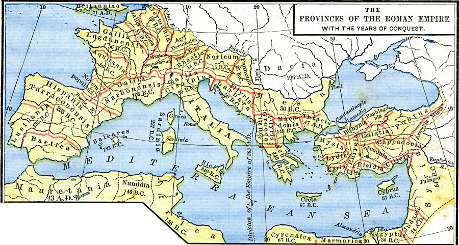
Description: A map of the provinces of the Roman Empire showing the years of conquest. The provinces include Sicilia (240 BC), Sardinia (237 BC), Baetica (206 BC), Hispania Tarraconensis (205 BC), Illyris Graeca (176 BC), Achaia (146 BC), Africa (Carthage – 146 BC), Lusitania (138 BC), Baleares (123 BC), Gallia Narbonensis (106 BC), Creta (67 BC), Cyrenaica (67 BC), Syria (64 (BC), Cyprus (57 BC), Aquitania (56 BC), Gallia Lugdunensis (56 BC), Gallia Belgica (51 BC), Gallia Cisalpina (50 BC), Illyris Barbara (50 BC), Numidia (46 BC), Germania (39 BC), Novem populana, Maxima Sequanorum, Agri Decumates, Pannonia (35 BC), Moesia (30 BC), Aegyptus (30 BC), Marmarica (30 BC), Noricum (15 BC), Rhaetia (15 BC), Mauritania (AD 43), Judaea (AD 44), Thracia (AD 47), Britannia (AD 71), and the territories of Dacia north of the Danube (AD 106). The map shows the boundary established between the West and East (Byzantine) Roman Empires in AD 395, and the provinces of Asia Minor, including Mysia, Bithynia, Paphlagonia, Pontus, Galatia, Armenia Minor, Cappadocia, Lydia, Caria, Phrygia, Lycia, Pisidia, and Cilicia.
Place Names: Regional Mediterranean, Africa, �France, �Italy, �Spain, �Syri
ISO Topic Categories: borders, kRomanEmpire, kWorldMedSea, kWorldAfroAsia, kWorldEurasia, kWorldEuroAfrica
Keywords: The Provinces of the Roman Empire within the Years of Conquest, borders, kRomanEmpire, borders, kRomanEmpire, kWorldMedSea, kWorldAfroAsia, kWorldEurasia, kWorldEuroAfrica, Unknown, AD 116
Source: Robert H. Labberton, New Historical Atlas and General History (New York, NY: Townsend MacCoun, 1886) Plate XIX
Map Credit: Courtesy the private collection of Roy Winkelman |
|