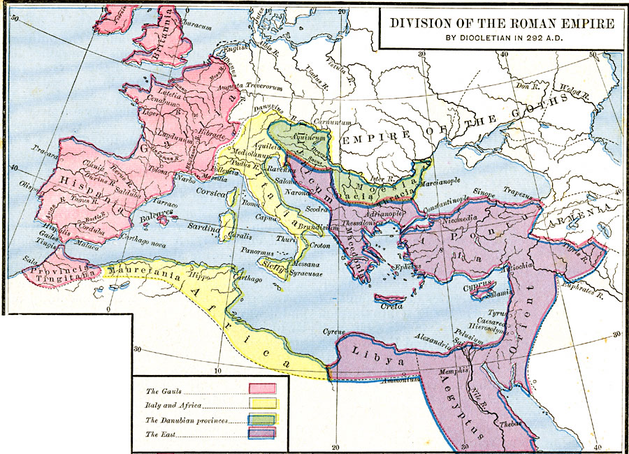
Description: A map showing the division of the Roman Empire by Diocletian in AD 292. This map is color–coded to show the territories of the Gauls, the Latin Romans, Byzantine Romans, and the Danubian Provinces, and includes the territory of the Empire of the Goths. The territories of the Gauls include Britannia, Gallia, Hispania, and the North African Provincia Tingitana. The Latin territories include Italia, Sicily, Corsica, Sardinia, and North African Mauretania. The Danubian Provinces include the northern portion of Illyricum, Dacia, and Moesia, and the Byzantine territories include the southern portion of Illyricum, Macedonia, Pontus, Orient, Aegyptus, and Libya. Important cities of the time are shown, as well as rivers.
Place Names: Regional Mediterranean, Africa, �Asia, �Armenia, �Egypt, �France, �Greece, �Italy, �Libya, �Spain, �Syri
ISO Topic Categories: borders, kRomanEmpire, kWorldMedSea, kWorldAfroAsia, kWorldEurasia, kWorldEuroAfrica
Keywords: Division of the Roman Empire by Diocletian, borders, kRomanEmpire, borders, kRomanEmpire, kWorldMedSea, kWorldAfroAsia, kWorldEurasia, kWorldEuroAfrica, Unknown, A.D. 292
Source: Robert H. Labberton, New Historical Atlas and General History (New York, NY: Townsend MacCoun, 1886) Plate XX
Map Credit: Courtesy the private collection of Roy Winkelman |
|