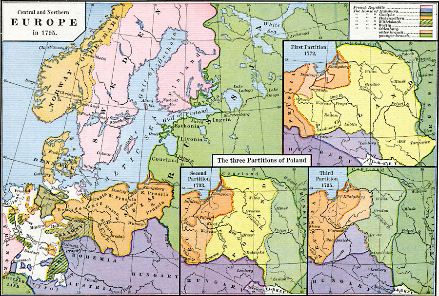
Description: This map of Central and Northern Europe in 1795 shows the extent of the royal houses of Europe, including the House of Habsburg in Austria, Hungary, and Bohemia, the House of Guelphs (or Welf) in Brunswick–Luneburg, the House of Hohenzollern in Prussia and Brandenburg, the House of Wittelsbach in Bavaria and Palatinate of the Rhine, the House of Wettin in Saxony, and the House of Oldenburg with the younger branch in Russia (Tsars) and the older branch in Denmark and Norway. The map also shows the Kingdom of Sweden, and portions of the French Republic and Switzerland. The inset maps show the three partitions of Poland, or the Polish–Lithuanian Commonwealth, between 1772 and 1795 by the Habsburgs, Hohenzollern, and younger branch of Oldenburg. Color tones show the original territories in darker tones, and the acquired territories in lighter tones.
Place Names: Western and Central Europe, Austria, �Bohemia, �Denmark, �Finland, �France, �Hungary, �Prussia, �Russia, �Sweden, �Switzerland, �Saxon
ISO Topic Categories: oceans,
location,
inlandWaters,
boundaries
Keywords: Europe and the Partition of Poland, borders, �political, kPartitionOfPoland, country borders, oceans,
location,
inlandWaters,
boundaries, Unknown, 1772–1795
Source: Robert H. Labberton, New Historical Atlas and General History (New York, NY: Townsend MacCoun, 1886) Plate XLIX
Map Credit: Courtesy the private collection of Roy Winkelman |
|