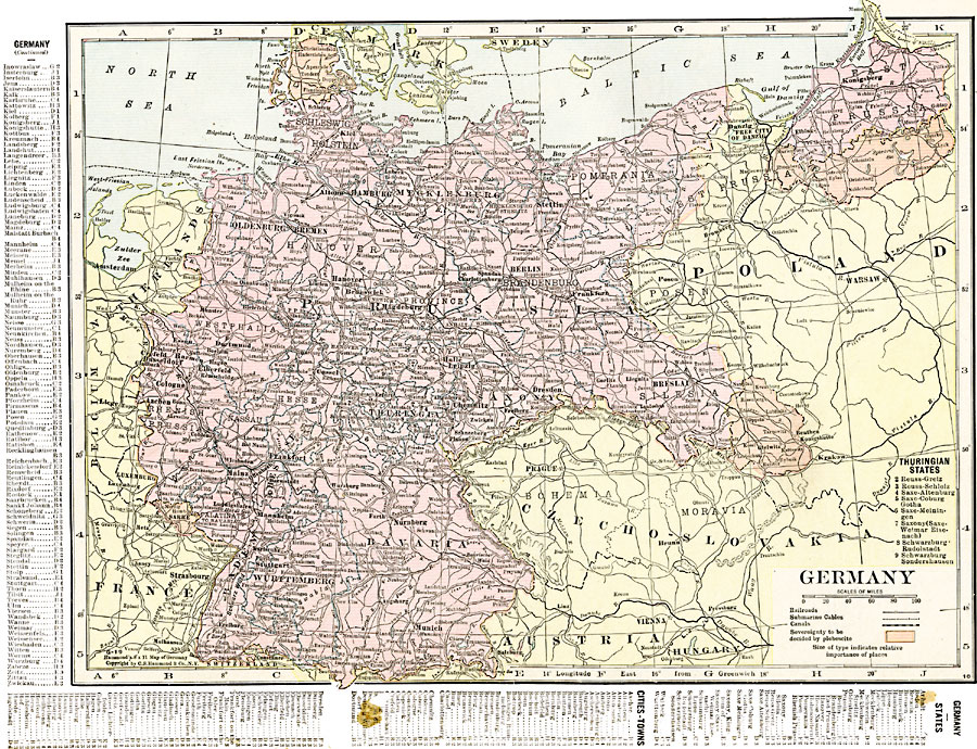
Description: A map of Germany in 1920, showing major cities, railroads, submarine cables, and canals, with a reference key to the nine Thuringian States. The map is color–coded to show the territories of southern Silesia, southern East Prussia, Sarre, and northern Schleswig, whose sovereignty was to be decided by plebiscite. This map includes a reference key to the German States, and principal cities and town of Germany.
Place Names: Germany, Baden, �Bavaria, �Berlin, �Bremen, �Cologne, �Dresden, �Frankfurt am Main, �Hamburg, �Hannover, �Mainz, �Mannheim, �Mecklenburg, �Nuremberg, �Oldenburg, �Saxony, �Thuringia, �Wiesbade
ISO Topic Categories: oceans,
location,
inlandWaters,
boundaries
Keywords: Germany, borders, �political, �transportation, �historical, major political subdivisions,
country borders, railroads,
water routes, other military, oceans,
location,
inlandWaters,
boundaries, Unknown, 1920
Source: , The New Reference Atlas of the World - A New Series of Physical, Political and Historical Maps compiled from Government Surveys and exhibiting the Latest Results of Geographical Research (New York, NY: C. S. Hammond & Company, 1920) 43
Map Credit: Courtesy the private collection of Roy Winkelman |
|