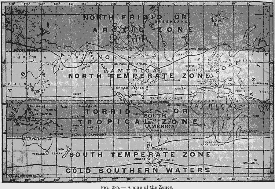
Description: A world map from 1910 showing the torrid, temperate, and frigid zones based on lines of latitude. "The boundaries of the torrid zone are easily fixed, because they mark the points farthest north and south where the sun's rays are vertical at some period of the year. On December 21, when the north pole is farthest within the shadow, the sun's rays are vertical as far south as the Tropic of Capricorn. On June 21, on the other hand, when the north pole is farthest within the light, the sun's rays are vertical as far north as the Tropic of Cancer. The north frigid zone is the region around the north pole that lies entirely in darkness on December 21 [Arctic Circle]. On June 21, this same region lies entirely in the light. The south frigid zone is the corresponding region about the south pole. The two temperate zones are merely the wide belts that lie between the torrid zone, on the one hand, and the frigid zones on the other." — Tarr, 1910, pp. 200-201.
Place Names: A Complete Map of Globes and Multi-continent, Africa, �Antarctica, �Asia, �Australia, �Europe, �North America, �South Americ
ISO Topic Categories: boundaries
Keywords: Map of Temperature Zones, time zones, kClimate, country borders, boundaries, Unknown, 1910
Source: Ralph S. Tarr, B.S., F.G.S.A. and Frank M. McMurry, Ph.D., New Geographies (Second Book) (New York , NY: The MacMillan Company, 1910) 200
Map Credit: Courtesy the private collection of Roy Winkelman |
|