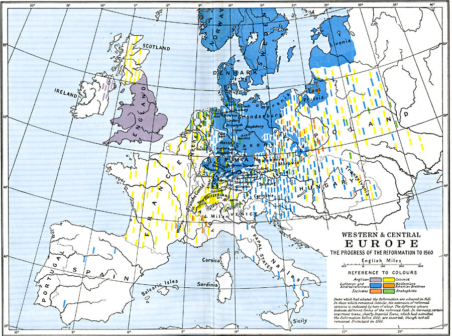
Description: A map of Western & Central Europe, subtitled "The Progress of the Reformation to 1560." The map is color–coded to show different forms of the reformed faith, including Anglican, Calvinist, Lutheran and kindred reformers, Waldensians Bohemian Brethren, Socinians, and Anabaptists. "States which had adopted the Reformation are coloured in full. In those which remained Catholic, the extension of reformed opinions is indicated by bars of colour. The different colours indicate different forms of the reformed faith. In Germany, certain important towns, chiefly Imperial Towns, which had admitted the Reformation before 1560, are inserted, though not all remained Protestant in 1560." — Ward, Prothero, and Leathes, 1912.
Place Names: Western and Central Europe, Denmark, �England, �France, �Germany, �Hungary, �Italy, �Livonia, �Netherlands, �Norway, �Scotland, �Sweden, �Switzerland, �Transylvani
ISO Topic Categories: oceans,
location,
inlandWaters,
boundaries
Keywords: Western and Central Europe, political, �religious, �statistical, kReformation, country borders,
major political subdivisions,
local jurisdictions, oceans,
location,
inlandWaters,
boundaries, Unknown, 1517–1560
Source: Ward, Prothero, and Leathes, The Cambridge Modern History Atlas (New York, NY: The Macmillan Company, 1912)
Map Credit: Courtesy the private collection of Roy Winkelman |
|