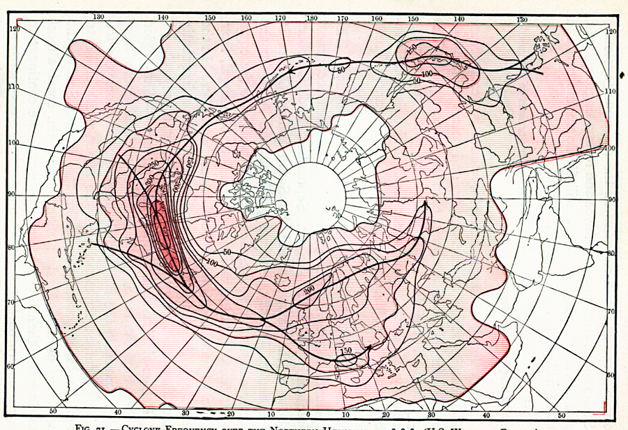
Description: A map from the U.S. weather Bureau of the northern hemisphere showing cyclone frequency in 1878–1887. The colored areas show the frequency of cyclones, with the darker areas indicating greater frequency, and the uncolored areas indicating little or no activity. "The direction of translation of cyclones for the middle latitudes is easterly, while for the lower latitudes it is westerly, corresponding to the direction of the air currents in the general atmospheric circulation at those latitudes. [...] The frequency of occurrence and region of maximum number of cyclones in various parts of the northern hemisphere are shown, where the numerals signify the number of cyclone centers which have passed, during a period of 10 years, over the regions along the lines. The heavy arrow lines show the most frequent paths. " — Waldo, 1896, pp. 225–229.
Place Names: Northern Hemisphere, Asia, �Europe, �North Americ
ISO Topic Categories: inlandWaters,
oceans,
climatologyMeteorologyAtmosphere
Keywords: Cyclone Frequency, physical, �meteorological, �hurricane, tropical storm, frequency, physical features, inlandWaters,
oceans,
climatologyMeteorologyAtmosphere, Unknown, 1878–1887
Source: Frank Waldo, Elementary Meteorology (New York, New York: American Book Company, 1896) 228
Map Credit: Courtesy the private collection of Roy Winkelman |
|