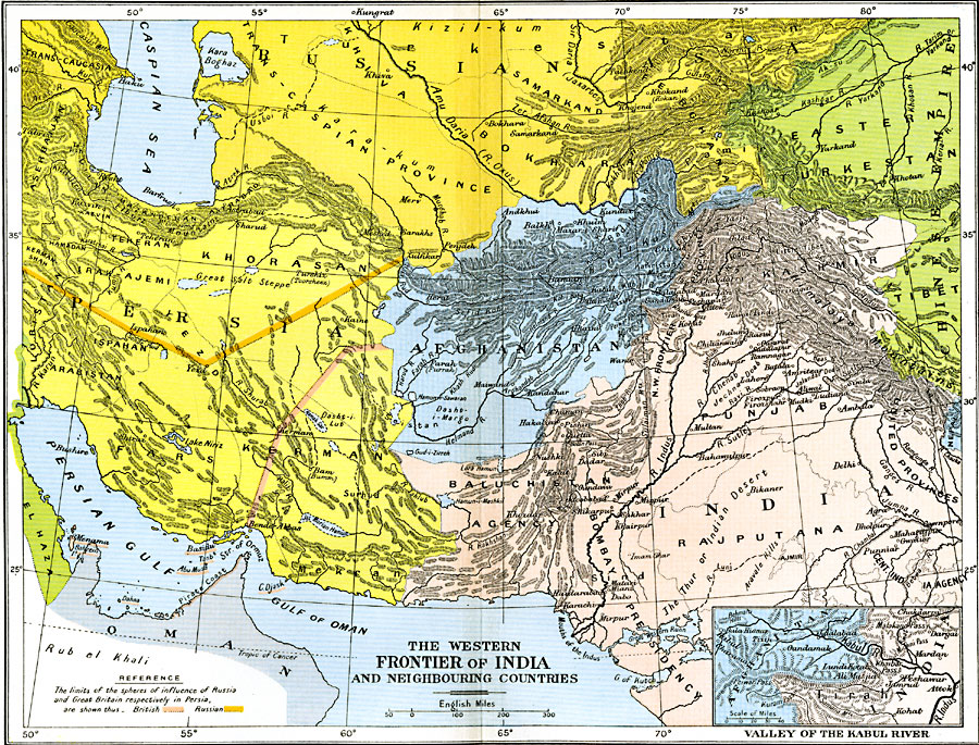
Description: A map of the western frontier of India, Afghanistan, Persia, and the southern Russian Empire between 1805 and 1910. The map is color–coded to show the territories of the British and Russian Empire at the time, and the spheres of influence of the British and Russians in Persia. The map shows provinces at the time, major cities, mountain systems and terrain features, deserts, lakes, rivers, and coastal features of the region. "The great colonizing movement which Russia had carried on from Moscow into Central Asia led the British, early in the nineteenth century, to look beyond the actual frontiers of India and to interest themselves in Sind, the Punjab, Afghanistan, and Persia. [...] The final annexation of the Punjab in 1849 carried the British frontier to the Afghan hills. Meanwhile, Russia advanced across the Kirghiz steppes, and gained control of the routes of communication with Central Asia. She came into touch with the Afghanistan and Persia on the west, at the moment when the British came into contact with Afghanistan and Baluchistan on the east." — Ward, Prothero, and Leathes, 1912, p. 107.
Place Names: Western Asia, Afghanistan, �Baluchistan, �Bombay, �China, �India, �Persia, �Punjab, �Rajputana, �Russi
ISO Topic Categories: oceans,
location,
inlandWaters,
boundaries
Keywords: The Western Frontier of India and Neighbouring Countries, political, �historical, country borders,
local jurisdictions,
major political subdivisions, historical event, oceans,
location,
inlandWaters,
boundaries, Unknown, 1805–1910
Source: Ward, Prothero, and Leathes, The Cambridge Modern History Atlas (New York, NY: The Macmillan Company, 1912)
Map Credit: Courtesy the private collection of Roy Winkelman |
|