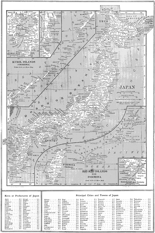
Description: A map from 1914 of the Japanese Islands, including Yezo (Hokkaido), Hondo (Honshu), Shikoku, and Kiushiu (Kyushu). Inset maps detail the Japanese possession of Formosa (Taiwan) and the Riu–Kiu (Ryukyu) Islands, the Kurile or Chishima Islands of northern Japan, the southern portion of Sakhalin Island (Japan had won the portion of the island south of 50° North latitude as a concession of the Russo–Japanese War of 1904–1905), Tokio (Tokyo) Bay, and the area around Nagasaki. Major cities, railways, rivers, islands, and coastal features are shown. This map has a grid–reference to Kens or Prefectures, and the major cities and towns of Japan in the bottom margin.
Place Names: Japan, Yokohama, �Tokyo, �Osaka, �Tokio, �Nagasaki, �Formosa, �Taiwan, �Kuril Islands, �Akita, ��Fukuoka, �Kobe, �Nagoya, �Sappor
ISO Topic Categories: boundaries,
location,
inlandWaters,
oceans
Keywords: Japan , physical, physical features, boundaries,
location,
inlandWaters,
oceans, Unknown, 1914
Source: , The New Encyclopedic Atlas and Gazetteer of the World (New York, NY: P. F. Collier and Son, 1914) 142
Map Credit: Courtesy the private collection of Roy Winkelman |
|