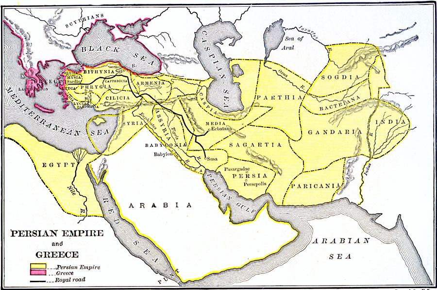
Description: A map of the Persian Empire at the time of Darius I (549–486 BC) and the Ionian Revolt (499–493 BC) between the Greeks and the Persians. The map is color–coded to show the Greek coastal settlements, and the Persian Empire extending from Anatolia to the Indus River in the east and Egypt to the south. The map shows the Persian Royal Road from Susa near the Persian Gulf to Sardis near the Aegean Sea. The Persian territories include Phrygia, Mysia, Lydia, Caria, Lycia, Bithynia, Cappadocia, Cilicia, Syria, Egypt, Assyria, Babylonia, Armenia, Caspia, Media, Parthia, Sagartia, Persia, Sogdia, Bactriana, Gandaria, India (Indus River area), and Paricania.
Place Names: Regional Miscellaneous, Africa, �Asia, �Europ
ISO Topic Categories: political, �physical, �transportation, kWorldMedSea, kWorldAfroAsia, kWorldEurasia
Keywords: Persian Empire and Greece, political, �physical, �transportation, physical features, major political subdivisions, roads, political, �physical, �transportation, kWorldMedSea, kWorldAfroAsia, kWorldEurasia, Unknown, 560–490 B.C.
Source: George Willis Botsford, Ph. D., A History of Greece (London, : The Macmillan Company, 1912) 115
Map Credit: Courtesy the private collection of Roy Winkelman |
|