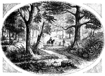
"View at King's Mountain battle-ground. This view is from the foot of the hill, whereon the hottest of the fight occurred. The north slope of that eminence is seen on the left. In the center, within a sort of basin, into which several ravines converge, is seen the simple monument erected to the memory of Ferguson and others; and in the foreground, on the right, is seen the great tulip-tree, upon which, tradition says, ten Tories were hung."—Lossing, 1851

King's Mountain Battle-Ground

"View at King's Mountain battle-ground. This view is from the foot of the hill, whereon the hottest…
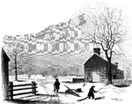
"View of the battle-ground near Princeton. This view, looking north, is from the carriage gate of Mr. John Clarke, owner of the house in which General Mercer died, which is situated about seventy rods from the Trenton turnpike. That dwelling is represented in the foreground of the picture, on the extreme right. The distant view includes almost the whole field of action. Near the center of the picture, over the head of the dark figure, is seen the house of William Clark, and his out-buildings. The barn, a little more to the left, with a tree in front, is upon the spot from whence Mercer rushed forward to the hedge-fence. That fence was upon the line of the present turnpike, denoted in the sketch by the fence passing down the slope beyond the large tree on the extreme left. The 'high ground' for which both parties were aiming, to secure advantage, is seen in the extreme distance. The dark spot between the tree in the second field and the barn denotes the spot where Mercer fell. The house of William Clark, in the distance, is about a quarter of a mile from the one in the foreground, where Mercer died. The hollow between the two houses was the space between the belligerents when Washington advanced to the support of Mercer. The place of conflict is about a mile and a quarter south of Princeton. The turnpike passes directly through it."—Lossing, 1851

Princeton battle-ground

"View of the battle-ground near Princeton. This view, looking north, is from the carriage gate of Mr.…
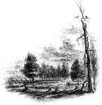
"The Regulator battle-ground. This view is from the south side of the Salisbury Road, which is marked by the fence on the left. The belligerents confronted in the open field seen on the north of the road, beyond the fence. Between the blasted pine, to which a muscadine is clinging, and the road, on the edge of a small morass, several of those who were slain in that engagement were buried. I saw the mounds of four graves by the fence, where the sheep, seen in the picture, are standing. The tree by the road side is a venerable oak, in which are a few scars produced by the bullets."—Lossing, 1851

Regulator Battle-ground

"The Regulator battle-ground. This view is from the south side of the Salisbury Road, which is marked…