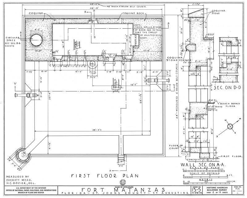
1934 Survey of Fort Matanzas, First Floor Plan, No. 15-5, US Department of the Interior, Office of National Parks, Sheet 2 of 12
This is a 1934 architectural design of the first floor plan of Fort Matanzas. The plan details the dimensions of the fort (48' X 48'), thickness of the walls and specifies the structure be built from coquina rock. The plans also details the measurements for the fireplace, sentry box, powder magazine, wall thickness, and location of cannons. Plans produced by the Historic American Buildings Survey, U.S. Department of the Interior, National Park Services, Branch of Plans and Design. Survey No. 15-5, Sheet 2 of 12.Galleries:Fort Matanzas Architectural Drawings, Forts and Fortifications, St. JohnsKeywords:Fort Matanzas National Park, Forts, National Monument, Saint Augustine, Spanish fort, St. Augustine, St. Johns County, floor plan, surveyPhoto Location: Fort Matanzas National Monument, St. Johns County, FloridaPhotographer: H. C. DozierDate of Photo: 04/11/1934Original Dimensions: 6000×4815Picture Orientation: LandscapeGPS Coordinates: 29°42′55″N 81°14′21″WPicture Number: 26670
WARNING: You are about to download a 2.9 MB TIFF!
Normally such a large file is only needed for high quality printing purposes. If you are certain that you need such a large file, click the DOWNLOAD button to begin.
If you do not wish to download the large TIFF, just click the × in the top right-hand corner to close this alert.