Maps Site map
  Maps > Africa > Cape Verde
Site Map  

  Record   1   to   2  of   2

Historic and contemporary maps of Cape Verde for use in the K-12 classroom.
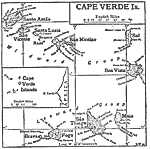
Cape Verde Islands, 1910
This is a detailed map of the Cape Verde Islands off of Africa. This shows the names of each island, the major cities and the separation of windward and leeward island groups. "Cape Verde Islands, an archipelago belonging to Portugal; off the We...

Cape Verde Islands, 1920
A map of the Cape Verde Islands in 1920, a possession of Portugal at the time....


  Maps > Africa > Cape Verde
Site Map  

Maps ETC is a part of the Educational Technology Clearinghouse
Produced by the Florida Center for Instructional Technology © 2009
College of Education, University of South Florida