Maps Site map
  Maps > Asia > A Regional Map of Asia
Site Map  

  Record   11   to   20  of   29

Historic and contemporary regional maps of Asia, including physical and political maps, early history and empires, climate maps, relief maps, population density and distribution maps, cultural maps, and economic/resource maps.

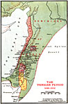
Palestine during the Persian Period, 536–332 BC
A map of the regions of Palestine during the Persian Period (536–322 BC) showing principal cities, mountains, rivers, and the dominions of Persia, Phoenicians, Kingdom of Damascus, Judah, and Edomites....

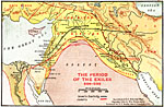
Period of the Exiles, 586–536 BC
A map of Egypt, Wilderness of Paran, Dominions of Babylon, and Media during the period of the exiles (586–536 BC) showing the principal cities of the region and the routes of Israel's captivity and Judah's route between Egypt and Media....

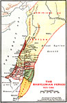
Palestine during the Babylonian Period, 605–586 BC
A map of the regions of Palestine during the Babylonian Period (605–586 BC) showing principal cities, mountains, rivers, and the dominions of Babylon, Phoenicians, Aramaeans, Ammonites, Philistines, Judah, Moabites, and Edomites....

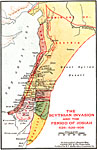
Palestine during the Scythian Invasion and the Period of Josiah, 639–608 BC
A map of the regions of Palestine after the Scythian invasion (628 BC) and the reign of Josiah (639–608 BC) showing principal cities, mountains, rivers, the route of the Scythians, and the dominions of Assyria, Phoenicians, Ammonites, Philistin...

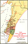
Palestine during the Fall of Israel and the Period of Hezekiah, 727–695 BCE
A map of the regions of Palestine after the fall of Israel (721 BC) and the reign of Hezekiah, king of Judah (727–695 BC) showing principal cities, mountains, rivers, and the dominions of Assyria, Phoenicians, Ammonites, Judah, Moabites, and Ed...

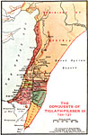
Palestine during the Conquests of Tiglath–Pileser III, 733–727 BC
A map of the regions of Palestine after the conquests of Tiglath–Pileser III, king of Assyria (733–727 BC), showing principal cities, mountains, rivers, and the dominions of Assyria, Phoenicians, Ammonites, Israel, Judah, Moabites, and Ed...

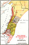
Palestine during the Period of Jeroboam II, 780–740 BC
A map of the regions of Palestine during the reign of Jeroboam II, king of Israel (780–740 BC), showing principal cities, mountains, rivers, and the dominions of Assyria, Phoenicians, Kingdom of Damascus, dominions of Israel, dominions of Judah...

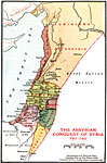
Palestine during the Assyrian Conquest of Syria, 797–783 BC
A map of the regions of Palestine after Assyria's conquest of Syria (797–783 BC), showing principal cities, mountains, rivers, and the dominions of Assyria, Phoenicians, Israel, Judah, Edomites, and Philistines....

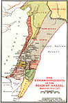
Palestine during the Syrian Conquests in the Reign of Hazael, 814–797 BC
A map of the regions of Palestine after the Syrian conquests during the reign of Hazael (814–797 BC), showing principal cities, mountains, rivers, and the territories of the Hittites, Assyrians, Syrians, Phoenicians, Israel, Judah, Ammonites, M...

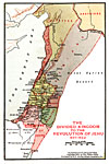
Palestine from the Time of the Divided Kingdom to the Revolution of Jehu, 937–842 BC
A map of the regions of Palestine from the Divided Kingdom to the Revolution of Jehu (937–842 BC), showing principal cities, mountains, rivers, and the territories of the Hittites, Assyrians, Syrians, Phoenicians, Israel, Ammonites, Moabites, D...

First Previous Next Last


  Maps > Asia > A Regional Map of Asia
Site Map  

Maps ETC is a part of the Educational Technology Clearinghouse
Produced by the Florida Center for Instructional Technology © 2009
College of Education, University of South Florida