Maps Site map
  Maps > Australia > Tasmania
Site Map  

  Record   1   to   2  of   2

Historic and contemporary maps of Tasmania, Australia, for use in the K-12 classroom.
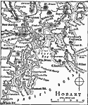
Hobart, 1919
A map from 1919 showing the area around Hobart, the capital of Tasmania. The map shows Storm Bay, the Tasman Peninsula, Maria Island, Whale Head, mountains, railways, and neighboring cities, towns, and ports, including Brighton, Dover, Adelaide, New ...

Tasmania, 1920
A map of Tasmania, Australia, in 1920, showing counties, cities and ports, railways, lakes, rivers, mountains, and coastal features....


  Maps > Australia > Tasmania
Site Map  

Maps ETC is a part of the Educational Technology Clearinghouse
Produced by the Florida Center for Instructional Technology © 2009
College of Education, University of South Florida