|
|
|
| Maps > Miscellaneous Maps > Map Drawing |
A collection of sketches and illustrations useful in developing map skills.
|
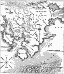
Typical Geographical Map Features,
1881 |
|
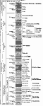
Geological Strata,
1881 |
|
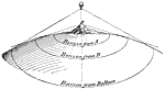
Horizons,
1908 |
|
A City Plan to Illustrate North and South Hemispheres,
1910 |
|
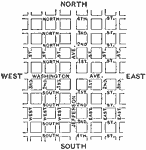
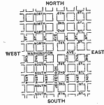
Naming Streets as Illustration of Latitude and Longitude,
1910 |
|
Contour Map of a Water Table,
1911 |
|
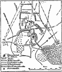
Defense of Towns and Villages,
1913 |
| Maps > Miscellaneous Maps > Map Drawing |
Maps ETC is a part of the Educational Technology Clearinghouse
Produced by the Florida Center for Instructional Technology © 2009
College of Education, University of South Florida