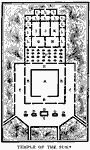
| Temple of the Sun, The modern structure of the convent of Santo Domingo, built in 1534, is at A, which contains in its contruction some remains of the walls of the older edifice. B is a cloister. C, an outer court. D, fountains for purification. E are streets leading to the great square of Cuzco. F, the garden where golden flowers were once placed; now used as a kitchen garden. G, the chapel dedicated to the moon. H, chapel dedicated to the rainbow. K, council hall of the grand pontiff and preists of the sun. L, the apartments of the priests and servents. |