Maps Site map
  Maps > Europe > Regional Maps >Western and Central Europe
Site Map  

  Record   101   to   110  of   121

Regional European maps of the Western and Central Europe region from the Maps ETC collection. This includes physical and political maps, early history and empires, WWI maps, climate maps, relief maps, vegetation maps, population density and distribution maps, cultural maps, and economic/resource maps.

The Merovingian Kingdoms, A.D. 507–613
A map of Western Europe showing the Merovingian Kingdoms from 507 till 613. This map is color–coded to show the territories of Neustria in western France, Burgundy in eastern France, Provence, and portions of Austrasia, Italy, and the territor...

Frankish Domain in the Time of Charles Martel, A.D. 732
A map showing the area more or less under Frankish dominion in AD 732, the time of Charles Martel, including Aquitaine, Neustria, Burgundy, Austrasia, and the territories of the Frisians and Bavarians. The site of the Battle of Tours (Battle of Poiti...

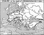
Europe at the Death of Charlemagne, A.D. 814
A map of Europe at the time of Charlemagne's death in AD 814 showing the extent of the Kingdom of the Franks, which included the Kingdom of Italy, Frisia, Saxonia, Britannia, Limes Britannicus, Neustria, Thuringia, Aquitania, Wasconia, Limes Hispanic...

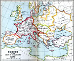
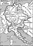
Europe at the Time of Charlemagne, A.D. 814
A map of Europe in AD 814, at the death of Charlemagne, showing the frontiers of Charlemagne's Empire, which included Neustria, Saxony, Austrasia, Aquitaine, Spanish March (or Marca Hispanica, the buffer zone created by Charlemagne in AD 795 between ...

Europe in the time of Charlemagne , A.D. 814
A map showing Europe in the time of Charlemagne, color–coded to show original possessions and lands taken over by Charlemagne. ...

The Western Empire as Divided at Verdun, A.D. 843
A map of Europe showing the division of the Western Empire upon the death of Charlemagne. The Kingdoms of Lothar, Lewis, and Charles are shown on the map. "The mighty empire of Charlemagne fell to pieces soon after his death. ‘His scepter ...

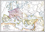
The Empire of Otto the Great divided into Duchies, A.D. 962
A map of Europe after the Empire of Otto the Great was divided into Duchies in AD 962. This map is color–coded to show the territories of the German Empire, which included Frisia, Lotharingia, Saxonia, Thuringia, Franconia, Bohemia, Bavaria, Al...

Empire of Otto the Great, A.D. 973
A map of Europe in AD 973 showing the empire of Otto the Great, emperor of the Holy Roman Empire. This map shows German states and duchies, and the Kingdom of Italy of the period, and includes portions of Denmark, Kingdom of France, Kingdom of Burgun...

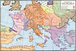
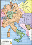
The Empire of Frederick II, AD 1215–1360
A map of the Empire of Frederick II, Holy Roman Emperor, 1215–1250, showing his hereditary possessions in Franconia and Swabia (Germany) and Sicily (including the southern portion of the Italian Peninsula), and the extent of his empire in centr...

Western Europe in the Time of Charles V, AD 1525
A map of Western and Central Europe in the Time of Charles V (1525), showing the political boarders and principal cities at the time. The map is Color–coded to show the Hereditary States of Charles V in yellow, and the boundary of the Holy Roma...

First Previous Next Last


  Maps > Europe > Regional Maps >Western and Central Europe
Site Map  

Maps is a part of the Educational Technology Clearinghouse
Produced by the Florida Center for Instructional Technology © 2009
College of Education , University of South Florida