Maps Site map
  Maps > United States > Meteorology
Site Map  

  Record   51   to   60  of   90

A collection of meteorological maps of the United States, including mean annual temperature maps, precipitation records and distribution, and typical storm event patterns.

Normal Surface Temperatures for July, 1911
A map from 1911 of the United States showing isotherms of mean surface temperatures in the region for the month of July....

Normal Surface Temperature for January, 1911
A map from 1911 of the United States showing isotherms of mean surface temperatures in the region for the month of January....

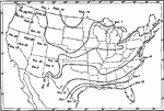
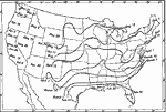
First Autumn Killing Frost, 1911
A map from 1911 of the United States showing the isolines of the average first killing frost in Autumn with typical dates given, and local variations in the Pacific and intermountain regions....

Last Killing Frost of Spring, 1911
A map from 1911 of the United States showing the isolines of the average last killing frost in Spring with typical dates given, and local variations in the Pacific and intermountain regions....

Mean Annual Precipitation in the United States, 1911
A map from 1911 of the United States showing the mean annual precipitation. Because precipitation includes snowfall, the measurements are reduced to equivalent measure of rainfall given in inches. This map shows the coastal and mountain effect on rai...

Absolute Minimum Temperatures in the United States, 1911
A map from 1911 of the United States showing the isolines of the average absolute minimum surface temperatures in the region. Temperatures are given in degrees Fahrenheit....

Average Humidity in the United States, 1911
A map from 1911 of the United States showing the isolines of the average annual relative humidity of the air in the region....

Annual Rainfall Percentage in Summer Months, 1911
A map from 1911 of the United States showing the percentage of annual rainfall received in the six warmer months, April to September inclusive....

United States Annual Rainfall, 1914
A map from 1914 of the United States showing the mean annual rainfall given in inches....

Average Annual Rainfall, 1916
A map from 1916 of the United States showing the average annual rainfall distribution, keyed to show areas of rainfall ranging from less than 10 inches to areas of over 60 inches per year. This map shows the coastal and mountain effect on rainfall di...

First Previous Next Last


  Maps > United States > Meteorology
Site Map  

Maps ETC is a part of the Educational Technology Clearinghouse
Produced by the Florida Center for Instructional Technology © 2009
College of Education, University of South Florida