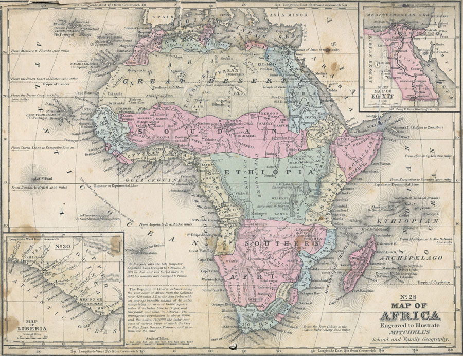
Description: Map of Africa in 1858, prior to the extensive European colonization of the continent established at the Berlin Conference of 1885. This map shows the European possessions of the Cape Colony, Natal, and Orange River Free State, and the native African States of Caffraria, Zoolus, Mozambique, Southern Africa, Lower Guinea, Ethiopia, Zanguebar, Somaulies, Abyssinia, Soudan, Upper Guinea, Liberia, Sierra Leone, Senegambia, Great Desert, Morocco, Algeria, Tunis, Tripoli, Barbary, Barca, Egypt, Bergoo or Waday, Darfur, Madagascar, and Kordofan. Ethiopia is shown as a native state in the Congo basin in central Africa. The names of the major African tribes for each area are underlined on the map. There is an inset map of Liberia, a colony founded in 1822 by freed slaves from the United States, with the following description: "The Republic of Liberia extends along the west coast of Africa from the Gallinas River, 420 miles S.E. to the San Pedro, with an average breadth inland of 40 miles comprising an area of 16,800 square miles. It includes Liberia Proper; and Maryland, and Ohio, in Liberia. The immigrant population is about 6000, and the native 140,000, the latter consists of various tribes of which the Veys or Feys, Bassas, Fishmen, and Kroomen, are the chief." Near the island of St. Helena is the note: "In the year 1815, the late Emperor Napoleon I was brought to St. Helena. In 1821 he died and was buried there. In 1840, his remains were conveyed to France." A second inset map details the Nile Delta, showing railroad routes, and the proposed location of the modern Suez Canal, which began construction in 1858, the same year this map was produced. There are several geographic notations indicating distances on this map, including the note that from Morocco to Florida is 4200 miles. Major trade centers, salt mines, trade and caravan routes are shown, as well as the routes of several European explorers, including Livingston, Barth, Petherick, Burton and Speke.
Place Names: A Complete Map of Africa, Algeria, �Congo, �Egypt, �Ethiopia, �Madagascar, �Somalia, �South Africa, �Sudan, �Cape Colony, Caffraria, Natal, Zoolus, Orange River Free State, Mozambique, Southern Africa, Lower Guinea, Ethiopia, Zanguebar, Somaulies, Abyssinia, Soudan, Upper Guine
ISO Topic Categories: boundaries,
inlandWaters,
location,
oceans
Keywords: Pre-Colonial Africa, political, �physical, kAfricanNativeStates, kBerlinConference, kNapoleonBonaparte, kSuezCanal, physical features, country borders, boundaries,
inlandWaters,
location,
oceans, Unknown, 1858
Source: , Mitchell's School Atlas (Philadelphia, Pennsylvania: E. H. Butler & Co., 1863)
Map Credit: Courtesy the private collection of Roy Winkelman |
|