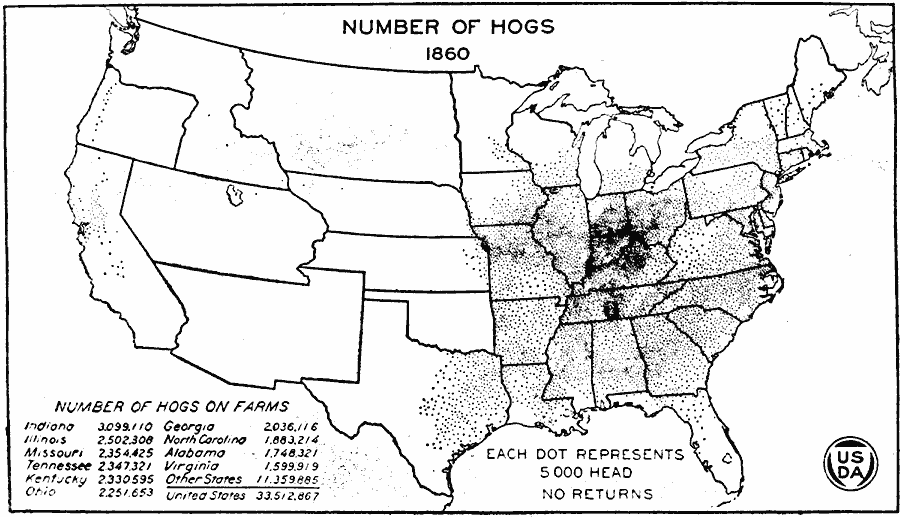
Description: A map of the United States from the U. S. Department of Agriculture (1923) showing the numbers and location of hogs produced in the United States in 1860. "In the Mississippi Valley production continued to increase between 1850 and 1860 and expanded westward into Iowa, Nebraska, and Kansas. The areas of densest production were not far from Cincinnati, which was still the great packing center. Hogs had now become numerous in California." — United States Department of Agriculture Yearbook, 1923.
Place Names: Agriculture, Indiana, Illinois, Missouri, Tennessee, Kentucky, Ohio, Georgia, North Carolina, Alabama, Virginia, �hog
ISO Topic Categories: boundaries,
inlandWaters,
oceans,
farming
Keywords: United States Production of Hogs, physical, �political, �statistical, �production of hogs by united states in 1860, swine, pigs, pork, kAgriculture, physical features, country borders,
major political subdivisions, agriculture, boundaries,
inlandWaters,
oceans,
farming, Unknown, 1860
Source: , United States Department of Agriculture Yearbook 1922 (Washington, DC: Government Printing Office, 1923) 188
Map Credit: Courtesy the private collection of Roy Winkelman |
|