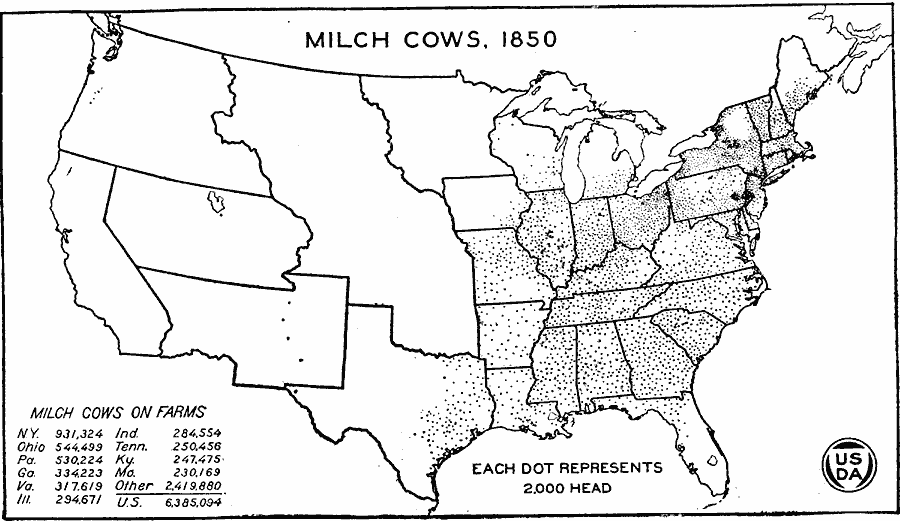
Description: A map of the United States from the U. S. Department of Agriculture (1922) showing the distribution of Milch Cows in the United States in 1850. "In 1850 cows were numerous in southern New England, Vermont, southern and central New York, in northern New Jersey, in southeastern Pennsylvania, and in northeastern Ohio. Outside of these areas they were quite evenly distributed over the settled part of the United States." — United States Department of Agriculture Yearbook 1922, 1923.
Place Names: Agriculture, New York, Ohio, Pennsylvania, Georgia, Virginia, Illinois, Indiana, Tennessee, Kentucky, Massachussetts, �cattl
ISO Topic Categories: boundaries,
inlandWaters,
farming
Keywords: Milch Cow Distribution, physical, �political, �statistical, �milch cow distribution, milk cow, dairy cow, kAgriculture, physical features, country borders,
major political subdivisions, agriculture, boundaries,
inlandWaters,
farming, Unknown, 1850
Source: , United States Department of Agriculture Yearbook 1922 (Washington, DC: Government Printing Office, 1923) 298
Map Credit: Courtesy the private collection of Roy Winkelman |
|