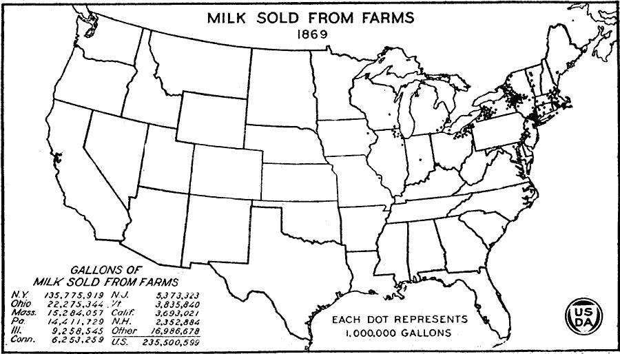
Description: A map of the United States from the U. S. Department of Agriculture (1923) showing the number of gallons of milk sold from farms in 1869 by state. "Probably the greater part of the milk sold from farms in 1869 was whole milk for cities. Some of it went to noncooperative cheese factories. Compare with maps of cheese made on farms 1869." — United States Department of Agriculture Yearbook 1922, 1923.
Place Names: Agriculture, New York, Ohio, Massachusetts, Pennsylvania, Illinois, Connecticut, New Jersey, Vermont, California, New Hampshire, �dairy product
ISO Topic Categories: boundaries,
inlandWaters,
farming,
economy
Keywords: Milk Sold from Farms, physical, �political, �statistical, �milk sold from farms, milk production in gallons by state, kAgriculture, physical features, country borders,
major political subdivisions, agriculture,
economic, boundaries,
inlandWaters,
farming,
economy, Unknown, 1869
Source: , United States Department of Agriculture Yearbook 1922 (Washington, DC: Government Printing Office, 1923) 302
Map Credit: Courtesy the private collection of Roy Winkelman |
|