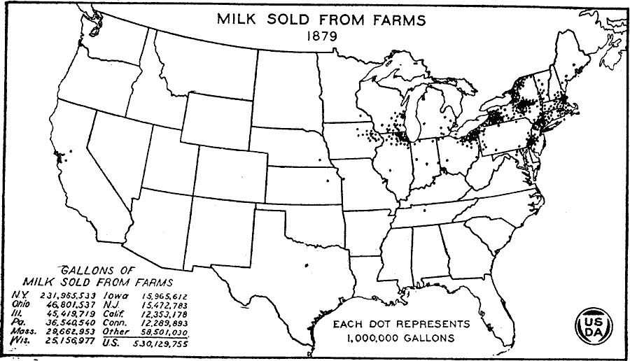
Description: A map of the United States from the U. S. Department of Agriculture (1922) showing the number of gallons of milk sold from farms in 1879 by state. "The milk supply zones about the larger cities expanded between 1869 and 1879. Note the Philadelphia, New York, Boston, and Chicago areas. Cleveland and Buffalo took some of the milk from northeastern Ohio and western New York, but most of it went to cheese factories." — United States Department of Agriculture Yearbook 1922, 1923.
Place Names: Agriculture, New York, Ohio, Illinois, Pennsylvania, Massachusetts, Wisconsin, Iowa, New Yersey, California, Connecticut, �dairy product
ISO Topic Categories: boundaries,
inlandWaters,
farming,
economy
Keywords: Milk Sold from Farms, physical, �political, �statistical, �milk sold from farms, milk production in gallons by state, kAgriculture, physical features, country borders,
major political subdivisions, agriculture,
economic, boundaries,
inlandWaters,
farming,
economy, Unknown, 1879
Source: , United States Department of Agriculture Yearbook 1922 (Washington, DC: Government Printing Office, 1923) 303
Map Credit: Courtesy the private collection of Roy Winkelman |
|