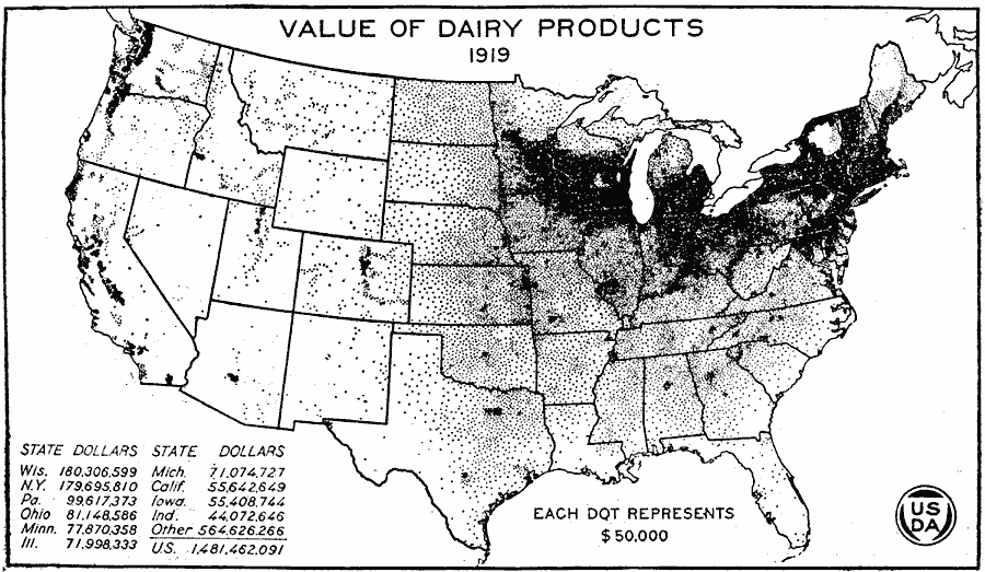
Description: A map of the United States from the U. S. Department of Agriculture (1922) showing the dollar value of dairy products in 1919 by state. "This map presents a striking contrast to the map for 1839. The value of the dairy products of the Rocky Mountain States in 1919 was greater than that of the United States in 1839. Prices were much inflated in 1919, $50,000 being equivalent to about $28,400 in 1839, which makes the difference appear greater than it actually is. The following maps will show steps in the changes between 1839 and 1919." — United States Department of Agriculture Yearbook 1922, 1923.
Place Names: Agriculture, Wisconsin, New York, Pennsylvania, Ohio, Minnesota, Illinois, Michigan, California, Iowa, Indiana, �dairy product
ISO Topic Categories: boundaries,
inlandWaters,
farming,
economy
Keywords: Value of Dairy Products, physical, �political, �statistical, �dollar value dairy product by state, kAgriculture, physical features, country borders,
major political subdivisions, agriculture,
economic, boundaries,
inlandWaters,
farming,
economy, Unknown, 1919
Source: , United States Department of Agriculture Yearbook 1922 (Washington, DC: Government Printing Office, 1923) 305
Map Credit: Courtesy the private collection of Roy Winkelman |
|