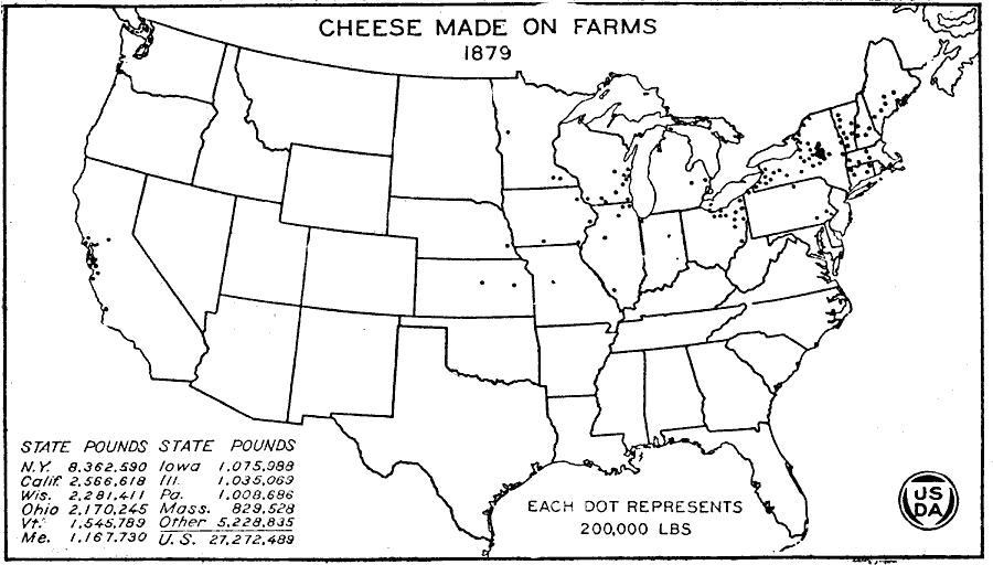
Description: A map of the United States from the U. S. Department of Agriculture (1922) showing the distribution of cheese made on farms by state in 1879. "By 1879 cheese production on the farm had dwindled to one–ninth of the total production. The old centers of farm production, however, can still be recognized. A dot appears for the first time in Nebraska, also in the Red River Valley of Minnesota." — United States Department of Agriculture Yearbook 1922, 1923.
Place Names: Agriculture, New York, California, Wisconsin, Ohio, Vermont, Maine, Iowa, Illinois, Pennsylvania, Massachusetts, �chees
ISO Topic Categories: boundaries,
inlandWaters,
farming,
economy
Keywords: Cheese Made on Farms, physical, �political, �statistical, �cheese made on farms, cheese production by state, kAgriculture, physical features, country borders,
major political subdivisions, agriculture,
economic, boundaries,
inlandWaters,
farming,
economy, Unknown, 1879
Source: , United States Department of Agriculture Yearbook 1922 (Washington, DC: Government Printing Office, 1923) 308
Map Credit: Courtesy the private collection of Roy Winkelman |
|