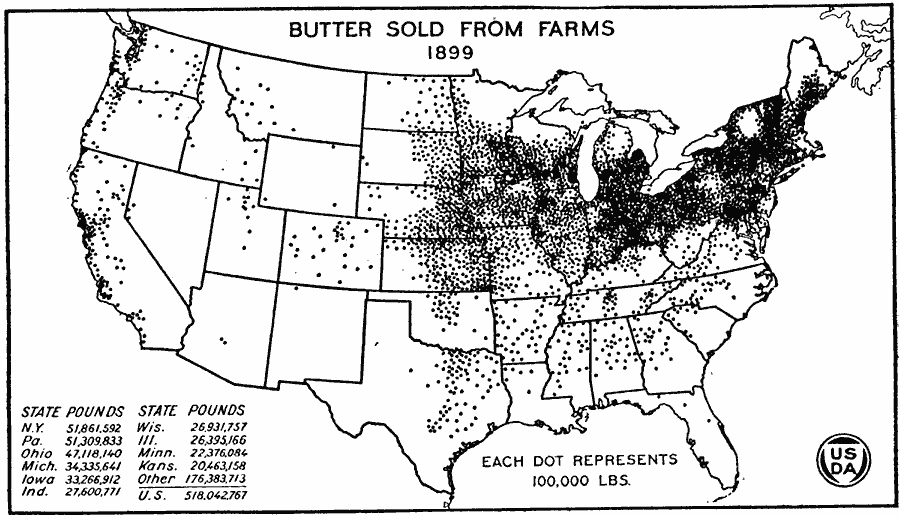
Description: A map of the United States from the U. S. Department of Agriculture (1922) showing the amount of butter sold from farms (in pounds) in 1899 by state. "This map marks well the areas of commercial dairying. In the South as a rule cows were kept only to supply home needs. Much of the butter and all of the cheese consumed in the South was produced in the North. The farm production of butter for market in 1899 was in the hay and pasture region of the northeastern and Lake States, with a less dense production in the Corn Belt." — United States Department of Agriculture Yearbook 1922, 1923.
Place Names: Agriculture, New York, Pennsylvania, Ohio, Michigan, Iowa, Indiana, Wisconsin, Illinois, Minnesota, Kansa
ISO Topic Categories: farming,
boundaries,
economy,
inlandWaters
Keywords: Butter Sold From Farms, physical, �political, �statistical, �butter sold from farms by state, kAgriculture, physical features, country borders,
major political subdivisions, agriculture,
economic, farming,
boundaries,
economy,
inlandWaters, Unknown, 1899
Source: , United States Department of Agriculture Yearbook 1922 (Washington, DC: Government Printing Office, 1923) 312
Map Credit: Courtesy the private collection of Roy Winkelman |
|