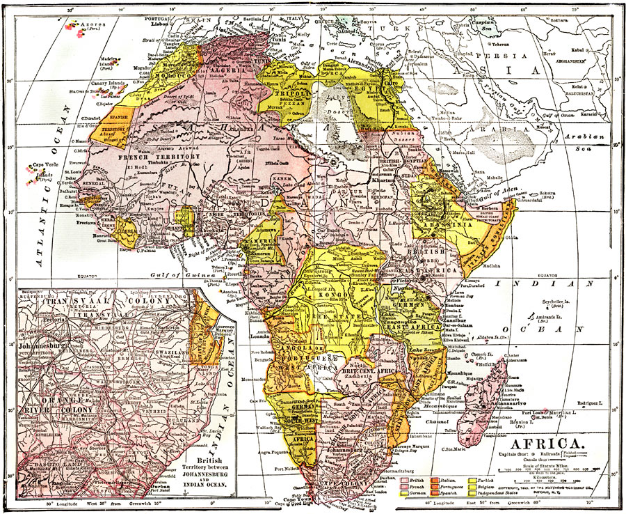
Description: "Africa – Second only to Asia in point of size, the continent of Africa, including the islands contiguous to its shore, has an area of 11,854,000 square miles, yet is the least important of all the great divisions of the globe, judged by the standard of civilization and commercial prosperity. It is only within a few years past that the true quality of the interior of Southern Africa has become known, through the researches of European and American explorers in the "dark continent." Attempts to colonize were begun by the French, on the west coast, in the seventeenth century, and at the Cape of Good Hope (the southern extremity of the continent, which was first doubled by Vasco da Gama) the Dutch established a port in 1650. An English trading company, a century later, also located here. The earliest explorers were James Bruce, who in 1772 visited Abyssinia and discovered the sources of the Blue Nile, and Mungo Park, who ascended the Niger in earlier years of the present country, and was killed in 1806 in the kingdom of Houssa by the natives. The desire to discover the source of the Great Nile has impelled several explorers to pierce Central Africa. Up to his time, the most successful of these was Dr. David Livingstone, who traveled in 1849 through the country watered by the Zambesi, and made a vast number of important discoveries. Burton, Speke, and Baker, in their hunt for the Nile's headwaters, discovered lakes Tanganyika, Victoria Nyanza and Albert Nyanza, which were also visited by Livingstone, who defined the great water system of the Lualaba or Chambeze. Henry M. Stanley, an American journalist, acting in the capacity of special correspondent of the New York Herald, visited Africa on a commission to find Livingstone, who had not been heard from for some years, and in 1871 he discovered him at Ujiji in great destitution, but still anxious to press forward into the continent, for which he had organized a new expedition. In 1873 Livingstone died, and in the following year his body was brought home and interred in Westminster Abbey. Stanley, after parting with Livingstone, explored the Congo, and has since made discoveries which place him in the front rank of African travelers. Commerce is following fast in the footsteps of these adventurous men, and colonization of the fertile territories they have visited and described is only a matter of time. In 1890 France owned 2,300,248 square miles; Germany, 1,035,720; Great Britain (1897), 2,587,755; Italy, 360,000; Spain, 210,000; Portugal, 774,993; while Congo Free State comprised 1,000,000 and Liberia about 14,300. A few changes have since been made." — Wark 1904
Place Names: A Complete Map of Africa, Algeria, �Egypt, �Congo, �Ethiopia, �Madagascar, �Morocco, �Angola, �British South Africa, �Abyssinia, �Italian Somaliland, �Sudan, �Kamerun, �Liberia, �Tripol
ISO Topic Categories: society
Keywords: Africa, physical, �political, �transportation, kBerlinConference, physical features,
topographical, country borders, railroads, society, Unknown, 1904
Source: Henry Wark, ed. , Wark's Modern Educator (New York, NY: Henry Wark, 1904) 933
Map Credit: Courtesy the private collection of Roy Winkelman |
|