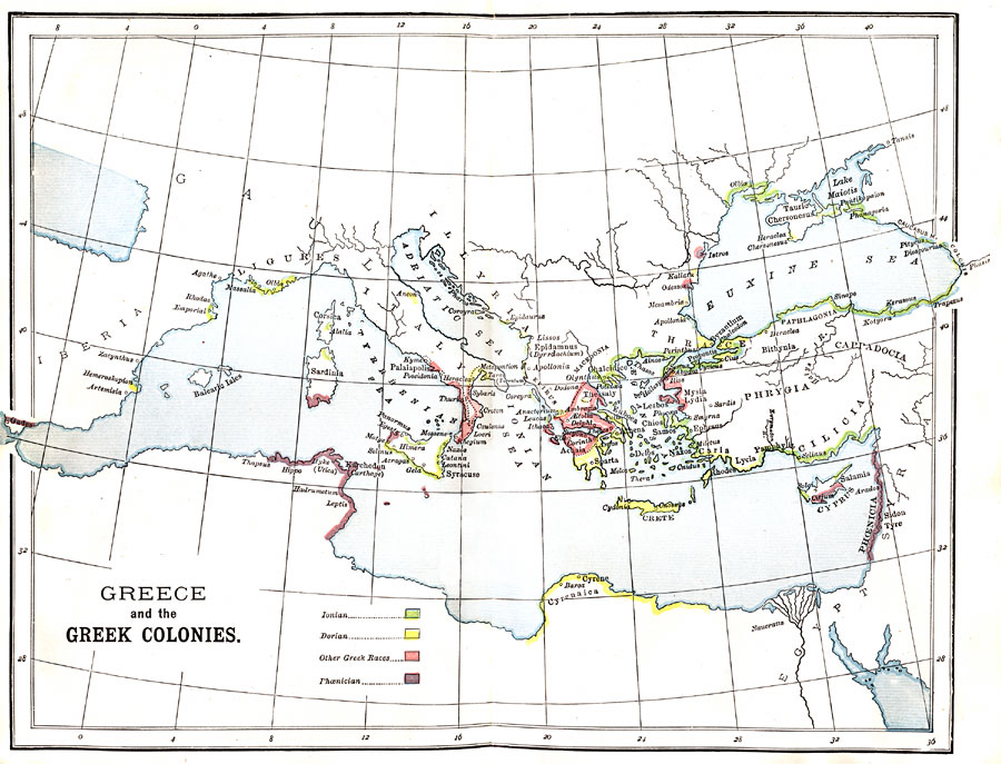
Description: Map of the Greek colonies showing which areas were colonized by different Greek races."The Age of the Tyrants coincides very nearly with the era of greatest activity in the founding of new colonies. Thousands, driven from their home, like the Puritans in the time of the Stuart tyranny in England, fled over the seas, and, under the direction of the Delphian Apollo, laid upon remote and widely separated shores the basis of 'Dispersed Hellas.' The overcrowding of population and the Greek love of adventure also contributed to swell the number of emigrants. During this colonizing era Southern Italy became so thickly set with Greek cities as to become known as Magna Græcia, 'Great Greece.' Here were founded during the latter part of the eighth century B. C. the important Dorian city of Tarentum; the wealthy and luxurious Achæan city of Sybaris (whence the term sybarite, meaning a voluptuary); the Great Crotona, distinguished for its schools of philosophy and its victors in the Olympian games. Upon the island of Sicily was planted, by the Dorian Corinth, the city of Syracuse (734 B.C.), which, before Rome had become great, waged war on equal terms with Carthage. In the Gulf of Lyons was established about 600 B.C. the important Ionian city of Massalia (Marseilles), the radiating point of long routes of travel and trade. On the African coast was founded the great Dorian city of Cyrene (630 B.C.), and probably about the same time was established in the Nile delta the city of Naucratis, through with the civilization of Egypt flowed into Greece. The tide of emigration flowed not only to the west and south, but to the north as well. The northern shores of the &Aelig;gean and those of the Hellespont and the Propontis were fringed with colonies. The Argonautic terrors of the Black Sea were forgotten or unheeded, and even those remote shores received their emigrants. Many of the settlements in that quarter were established by the Ionian city of Miletus, which swarming like a hive, became the mother of more than eighty colonies." —Myers, 1896
Place Names: Greece, Athens, �Mediterranean Sea, �Italy, �Crete, �Euxine Sea, �Ionian Sea,
ISO Topic Categories: society,
boundaries,
oceans,
inlandWaters
Keywords: Greece and the Greek Colonies, statistical, �physical, kAncientGreece, physical features, ethnological, society,
boundaries,
oceans,
inlandWaters, Unknown, 734–600 BC
Source: P. V. N. Myers, A General History for Colleges and High Schools (Boston, MA: Ginn & Company, 1896) 110
Map Credit: Courtesy the private collection of Roy Winkelman |
|