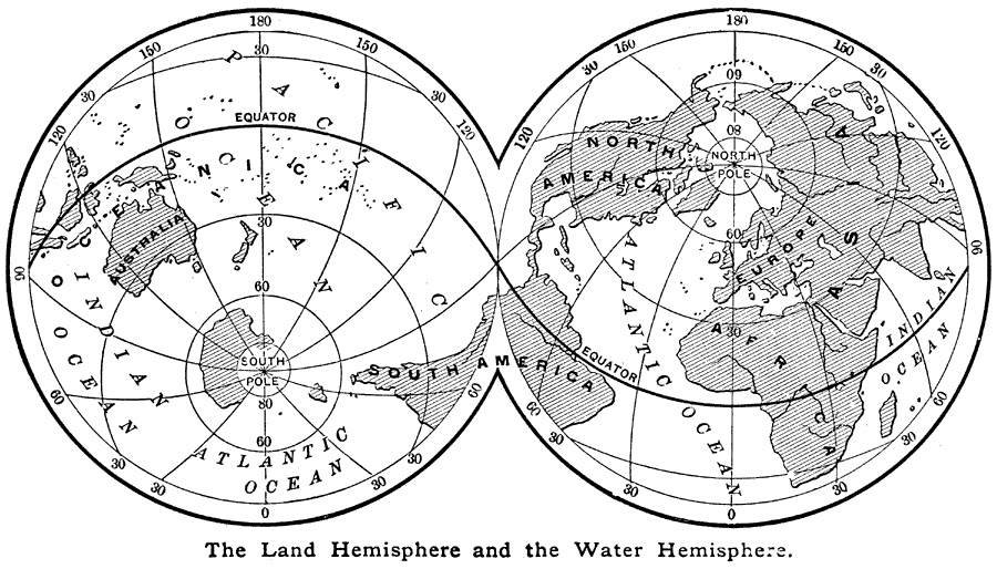
Description: "The portions of the land —the continents and the islands— are very irregular in shape, and are unequally distributed over the globe. By far the greater portion of the land lies north of the equator. There are also what are called a Land Hemisphere and a Water Hemisphere. If there should be constructed about the earth an imaginary great circle which should pass through Peru and the Malay Peninsula, and with one of the poles a little south of London in England, this circle would divide the globe into these two hemispheres. One would contain Europe, Asia, Africa, North America, and many large islands. This hemisphere would include six–sevenths of the land, while the other would consist almost entirely of water." (— Brewer, 1890)
Place Names: A Complete Map of Globes and Multi-continent, Africa, �Antarctica, �Asia, �Australia, �Europe, �North America, �South America, �Pacific Ocean, �Atlantic Ocean, �Indian Ocean,
ISO Topic Categories: oceans
Keywords: The Land Hemisphere and the Water Hemisphere, physical, kMapProjection, physical features, oceans, Unknown, 1890
Source: William H. Brewer Ph.,D., Warren's New Physical Geography (Philadelphia, PA: Cowperthwait and Company, 1890) 28
Map Credit: Courtesy the private collection of Roy Winkelman |
|