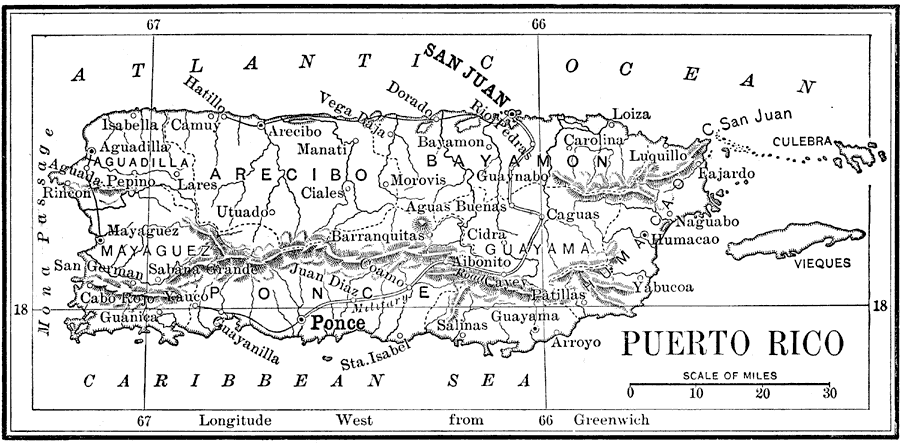
Description: A map from 1898 of Puerto Rico showing the capital of San Juan, departments, principal cities and towns, mountains, rivers, and coastal features. "Puerto Rico was ceded to the United States at the close of the Spanish war. It is a compact little island, less than one tenth the size of Cuba. Its length is 95 miles; its average breadth, 35 miles. The surface, especially in the northeastern part, is rugged and broken, but even on the tops of the highest hills vegetation flourishes and the soil admits to cultivation. The climate resembles that of Cuba. The average temperature in the summer is 83°, and in the winter 76°. The average yearly rainfall is about 60 inches, nearly the same as Louisiana. The number of flowing streams on the island is remarkable...Sugar and coffee are the chief agricultural products, the most extensive plantations being among the hills and uplands. In the lowlands large quantities of tobacco are raised. Rice and Indian corn are also abundant...Large herds of cattle are pastured on the plains. Horses of a superior breed are raised, and other domestic animals are numerous. Birds and insects exist everywhere in great variety; but the few wild animals are small, and there are no poisonous reptiles.&qout; — Redway, 1898.
Place Names: Puerto Rico, San Juan, �Ponce, �Aguadilla, �Mayaguez, �Guanica, �Bayamon, �Caguas, �Guayama, �Carolina, �Fajardo, �Salinas, �Pepino, �Rincon, �Mona Passage, �Isabella, �Haillo, �Camuy, �Arecibo, �Manati, �Dorado, �Rio Pedras, �Culebra, �Atlantic Ocean, �Caribbean S
ISO Topic Categories: boundaries,
elevation,
inlandWaters,
oceans,
transportation
Keywords: Puerto Rico, physical, �political, �transportation, �historical, physical features,
topographical, roads,
railroads,
water routes, boundaries,
elevation,
inlandWaters,
oceans,
transportation, Unknown, 1898
Source: Jacques W. Redway and Russell Hinman, Natural Advanced Geography (New York, NY: American Book Company , 1898) 3
Map Credit: Courtesy the private collection of Roy Winkelman |
|