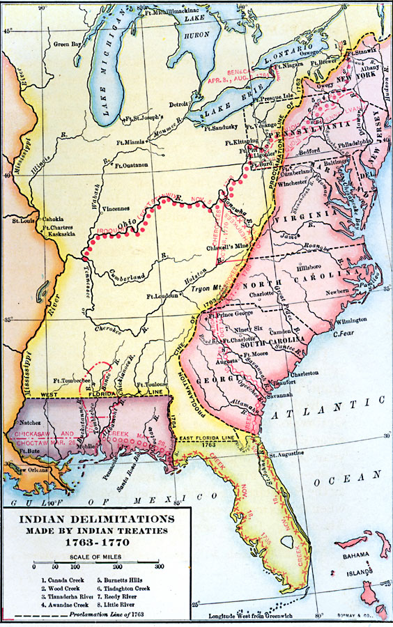
Description: A map of the American colonies and territories west to the Mississippi River between the end of the French and Indian War of 1763 and the beginnings of westward expansion of the trans–Appalachian colony proposed in the Vandalia Project (1770), shortly before the American Revolutionary War. The map shows the proclamation line of the British colonies established in 1763 that defined the western boundary of the colonies along the watershed divide of the Appalachian Mountains, and the various delimitation lines of Native American lands established by treaties between 1763 and the Treaty of Lochaber between Britain and the Cherokee (1770).
Place Names: Early America 1400-1800, New Orleans, �New York, �Native American
ISO Topic Categories: society,
inlandWaters,
location,
oceans,
boundaries
Keywords: Native American Delimitations, physical, �political, �statistical, kNativeAmerican, physical features, country borders,
major political subdivisions, ethnological,
population, society,
inlandWaters,
location,
oceans,
boundaries, Unknown, 1763–1770
Source: Albert Bushnell Hart, LL.D., The American Nation Vol 8 (New York, NY: Harper and Brothers, 1906) 224
Map Credit: Courtesy the private collection of Roy Winkelman |
|