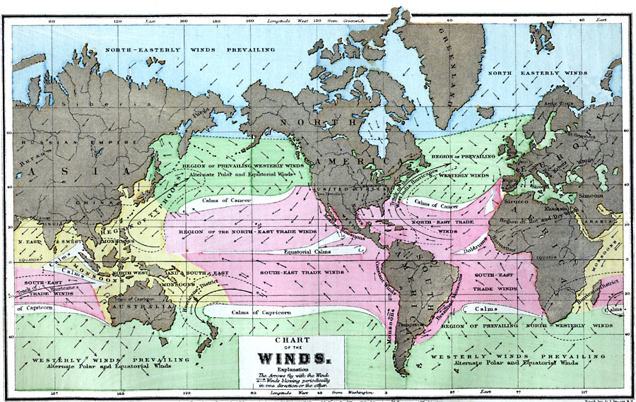
Description: A world map from 1873 showing the prevailing global wind patterns. The arrows on the map fly with the winds, and indicate regions where winds blow seasonally in one direction or another (monsoons of India for example). This map shows regions of calms and doldrums, typhoons, hurricanes, and the track of West India hurricanes, and is color–coded to show climate effects of the prevailing winds such as the North–Easterly, Westerly and Trade winds, and monsoons. The map shows longitude from Greenwich at the top of the map and longitude from Washington at the bottom.
Place Names: A Complete Map of Globes and Multi-continent, Africa, �Asia, �Australia, �Europe, �North America, �South Americ
ISO Topic Categories: climatologyMeteorologyAtmosphere,
inlandWaters,
location,
oceans
Keywords: Chart of Winds, physical, �political, �meteorological, kClimate, physical features, climate,
winds, climatologyMeteorologyAtmosphere,
inlandWaters,
location,
oceans, Unknown, 1873
Source: M. F. Maury, Physical Geography (New York, New York: University Publishing Company, 1885) 79
Map Credit: Courtesy the private collection of Roy Winkelman |
|