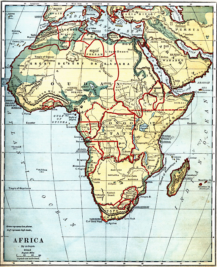
Description: A map of Africa as it was known in 1882 before the Berlin Conference of 1885, when the most powerful countries in Europe at the time convened to make their territorial claims on Africa and establish their colonial borders at the start of the New Imperialism period. In 1882 the two realms of greatest European influence were around the Cape Colony at the southern tip of the continent, and the Congo Free State controlled by Leopold II of Belgium. The Congo Free State, or Congo State, was established as a corporate state, similar to the British East India Company, for the purpose of developing a trade monopoly in Africa. This map shows the borders of Congo State by solid red lines, and the limit of free trade to the north and south by dashed red lines. This free trade zone essentially cut a swath for Belgium across central Africa from the Atlantic to the Indian Ocean. This map illustrates the contrast between the practice of native peoples in establishing natural territorial borders along rivers, mountain ranges, trade routes, or spheres of influence, and the typically European establishment of abstract cadastral or surveyed boundaries at the Berlin Conference. The map shows the native territories of the Zulu, Namaqua, Makalolo, Matebele, Sofala, Damara, Angola, Benguela, Mossa, Medes, Zanguebar, Congo, Sokoto, Darfoor, Schekka, Somali, Kordofan, Wadai, Bornu, Gando, Dahomey, Ashantee, and Tuat. Capitals and major cities are underlined, and this map is color-coded to show the low plains in green and the high lands in buff.
Place Names: A Complete Map of Africa, Spain, �Portugal, �Italy, �Turkish Empire, �Persia, �Arabia, �Nubia, �Egypt, �Zanguebar, �Mozambique, �Madagascar, �Cape Colony, �Congo State, �Lower Guinea, �Upper Guinea, �Fezzan, �Tripoli, �Algeria, �Marocc
ISO Topic Categories: boundaries,
inlandWaters,
location,
oceans
Keywords: Africa before the Berlin Conference, physical, �political, kAfricanNativeStates, kBerlinConference, kNaturalCadastralBoundaries, physical features, country borders, boundaries,
inlandWaters,
location,
oceans, Unknown, 1882
Source: , Guyot's New Intermediate Geography (New York, New York: Ivison, Blakeman & Company, 1882) 86
Map Credit: Courtesy the private collection of Roy Winkelman |
|