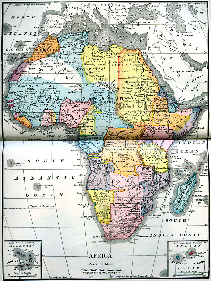
Description: A map of the African continent in 1906 showing European land claims such as British East Africa, German East Africa, Portuguese East Africa, Italian Somalia, and others, and European colonies and corporate states such as Cape Colony, Vaal River Colony (Transvaal), Rhodesia, and Congo Independent State. This map also shows several of the native territories marked by dashed lines. These native territories include Makolo Tribes, Damara Land, Great Namaqua Land, Sofala, Gasa, Bechuana Land, and Zulu Land in the south, Mossamedes, Benguela, Bakongo, Urua, Itawa, Lobisa, Watwa, Usango, Manyema, Uzinza, and Unyamuezi in central Africa, Somali, Galla, Nuer, Kordofan, Dar Fertit, Barca, Fezzan, Tuat, and Tibesti Country in the northeast and Barbary, and Adrar, Air, Kaarta, Bambara, Mandango, Masina, Songhay, Tombo, Mosi, Yoruba, Sokoto, and Adamawa in the west. Two inset maps include details of the Cape Verde Islands and the Mascaren (Mascarene) Islands of Reunion and Mauritius.
Place Names: A Complete Map of Africa, Algeria, �Egypt, �South Africa, �Congo Independent State, �Morocco, �Liberia, �Nubia, �Madagascar, Transvaal, Rhodesia, British Central Africa, Galla, Dar Foor, Tripoli, Tunis, Tirius, Sudan, Guinea, French Congo
ISO Topic Categories: boundaries,
transportation
Keywords: Africa, physical, �transportation, �political, kAfricanNativeStates, kBerlinConference, physical features, country borders, water routes, boundaries,
transportation, Unknown, 1906
Source: L. Brent Vaughan, Hill's Practical Reference Library of General Knowledge (Chicago, IL: Dixon, Hanson, & Company, 1906) second tab
Map Credit: Courtesy the private collection of Roy Winkelman |
|